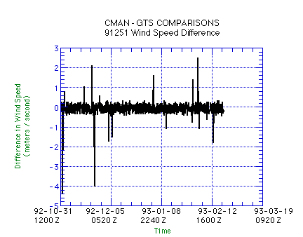
A Comparison of GTS and CMAN Surface Meteorological
Data Sets in the TOGA-COARE Region


Mark C. Bove

TOGA-COARE Surface Meteorological Data Processing Center
Center for Ocean-Atmospheric Prediction Studies
The Florida State University

1 April 1996

Report COAREMET 96-1


Contents:

I. Introduction
II. Methodology
III. Results and Discussion: Temperature and Pressure
III. Results and Discussion: Wind Direction and Speed
III. Results and Discussion: Summary
IV. Conclusions
V. Table and Figures


I. Introduction

The TOGA-COARE experiment, conducted from late 1991 to late 1993, was an attempt to gain an improved understanding of the role of the western tropical Pacific warm pool in both oceanic and atmospheric processes. A section of the warm pool, extending from 140° E to the International Date Line (180°), and from 10° N to 10° S, was the focal region for TOGA-COARE. Within this region are seven observing stations that participate in the Coastal Marine Automated Network (CMAN) which was operational during the TOGA-COARE Intensive Observation Period (IOP)
(Fig. 1). The IOP was a four month period, November of 1992 to February of 1993, during which a detailed meteorological investigation of the TOGA-COARE region took place. Four CMAN stations, Pagan (WMO ID#91222), Eniwetok Atoll (91251), Oroluk Island (91343), and Mili Atoll (91377), also transmit data over the Global Telecommunications System (GTS) every three hours. These CMAN stations recorded wind speed and direction, air temperature, and atmospheric pressure (Table 1).

In this report, the consistency of the data sets is checked by comparing each CMAN data set from the above locations with its GTS counterpart. The comparison was done for two reasons. The first was to determine which data set, CMAN or GTS, had better quality for use within the scientific community. The second was to verify the effectiveness of the Florida State University Data Processing Center / Data Archive and Distribution Center (FSU DPC/DADC) quality control procedures. As a result, the CMAN data have proved to be more accurate and detailed than their GTS counterparts. Furthermore, the quality control measures at the FSU DPC/DADC were successful in finding errors in data sets before their release to the scientific community.


II. Methodology

The CMAN data were made available to the FSU DPC/DADC by the
National Data Buoy Center (NDBC). The GTS data were made available by the National Center for Atmospheric Research (NCAR) through their Data Support Section (DSS). All data sets were translated by the FSU DPC/DADC into a common format and then quality controlled. The FSU DPC/DADC quality control is executed in two steps. First, all surface meteorological data are assessed with a low-level scan. This scan includes automated checks for coding errors, spurious spikes, instrument drift or failure, and unrealistic values. All suspect data are flagged. Each record is then visually inspected, and all assigned flags are investigated and may be modified by the inspector. The second level in the quality control process are the intercomparisons of data across platforms and instruments, but was not applied to these data sets before this analysis.

The GTS data sets had the same variables as the CMAN sets. The CMAN data are reported hourly, while the GTS data are reported every three hours. To compare atmospheric variables, the record for the CMAN were matched with the corresponding GTS record. The resulting matched data sets were visually inspected using the DPC/DADC Visual Data Assessment Tool (VIDAT). Both data sets were again checked graphically for any errors, spikes, or discontinuities, as well as consistency with each other. This was a repetition of the quality control process completed earlier, as well as a visual comparison of the data.

During the visual comparison, it was noticed that the wind speeds reported by the CMAN stations were consistently lower than their GTS counterparts. Closer inspection revealed that the CMAN wind speed magnitudes were about one-half the magnitudes of the GTS observations, indicating a possible problem involving the conversion of wind speeds from knots to meters per second in the GTS data. However, informational documents accompanying the original data indicated that both data sets were correctly formatted to meters per second. An inquiry to the NDBC then confirmed that the CMAN documentation was incorrect and the wind data from the CMAN station were not in knots, but in meters per second. As a result, the DPC/DADC converted the CMAN wind speeds to meters per second, and a new version (101) of the CMAN files were created.

The revised data sets for air temperature, atmospheric pressure, wind direction, and wind speed were again compared and differences (GTS data subtracted from the CMAN data) were then plotted graphically versus time, showing when and by how much the data sets deviated. After the initial graphs were analyzed, the numerical data were inspected to see if there were explanations for any deviations.


III. Results and Discussion: Temperature and Pressure

At Pagan, Eniwetok, and Oroluk, the differences in temperature and pressure indicated the data were mostly identical. However, there were occasional discrepancies between the two sets. The differences found were small; on average, the deviation between the data were less than one degree or millibar. Deeper inspection and a numerical comparison of the data sets failed to show whether the GTS or CMAN data were the cause of the deviations
(Fig. 2).

At Mili Atoll, the GTS temperature and pressure observations show a tendency to be half a unit higher than their CMAN counterpart (Fig. 3). Since the CMAN recorded both variables to the nearest tenth of a degree or millibar, and the GTS recorded the variables in whole numbers, it was initially

thought that rounding in the GTS data caused this skew. However, a rounding would result in differences centered around zero, which is not the case at Mili Atoll. If the GTS data were truncated upwards (e.g. 14.1 becomes 15.0), that would explain the skew. However, there is no way to confirm this hypothesis.


Wind Direction and Speed

Wind directions were recorded at Pagan, Oroluk, and Eniwetok to the nearest degree in the CMAN data, while their GTS counterpart reported wind direction data using a thirty-six point compass. This caused a consistent deviation in the differencing of up to five degrees. Visual inspection of the data, though, showed that if the CMAN data were rounded accordingly, it would match the GTS data.

Occasionally a major deviation of 100 degrees or more would appear in the wind directions (Fig. 4). Further investigation revealed that different methods of encoding calm winds caused the errors. In the GTS data, calm winds are labelled with a wind direction of 360 degrees and a wind speed of zero. However, the CMAN data recorded calm winds at the wind direction where the wind vane stopped when the wind went to zero. Thus, when the two wind directions were differenced, a large deviation resulted, when actually the data sets were both correctly reporting calm winds. These problems have been fixed in the final data sets.

GTS wind speeds were reported as integer values, CMAN data in tenths of a unit. Thus, rounding also caused errors in the wind direction when wind speeds were near calm; if the wind speed was below .5 m s-1, the GTS data would record a speed of 0, while the CMAN data still provided the decimal value. Thus, the GTS reported calm while the CMAN reported a non-zero wind, causing a wind direction deviation similar to the one described in the preceding paragraph, as well as a minor difference in the wind speed. Also, the rounding caused other minor deviations in the differences, but the mean of these deviations lies around zero, with a range between +0.5 and -0.5 m s-1. This indicates that the sets are comparable with each other (Fig. 5).

Occasionally, there are deviations in the wind speed data that can not be explained by rounding. There are no explanations for these differences, and they are not characteristic of any one data set. A possible source for deviations in the comparison of wind speeds can be due to non-uniform unit conversion factors from knots to meters per second.

Summary

In summary, the temperature and pressure data were very similar. There are occasional unexplained deviations, usually less than one millibar or degree, except for Mili Atoll, where the GTS data were on average .5 units higher than its CMAN counterpart. The wind direction and wind speeds agreed as well once proper units were determined, but rounding in the GTS data and problems with calm wind encoding caused deviations, but usually only ±.5 m s-1 in magnitude.

After discussing these results, the NDBC sent to the DPC/DADC additional metadata concerning the CMAN observing towers. All Pacific CMAN observing towers are equipped with two of each type of instrument (Fig. 6). It is known what instruments the distributed CMAN data originated from, but it is not known from which instruments the GTS data originated. Therefore, it is possible that the GTS data came from different instruments on the same tower. This easily explains the deviations in the wind speeds and wind directions, since wind speeds and directions can be different in a few meter's space. However, data from properly calibrated temperature and pressure sensors usually do not encounter a change of a degree or millibar over a few meter's distance. It is unlikely that different instruments are the cause for the large values in the temperature and pressure difference plots.

IV. Conclusions

After comparing the two data sets, it is clear that the CMAN data are significantly better for use by the scientific community than their GTS counterparts. Differencing the two data sets and investigating the deviations revealed that both data sets are good, but the CMAN data are superior to the GTS data in two ways. First, the CMAN data are hourly, instead of the three-hourly GTS data. The hourly data give much better resolution and provides a clearer picture of what was occurring at the stations. Second, the CMAN data values are not rounded, while the GTS regularly rounded values to the nearest whole degree, millibar, or meter per second. The absence of rounding in the CMAN data, like the hourly observations, make the CMAN data more desirable. Also adding to the CMAN's strength is the availability of metadata. The
NDBC has extensive information on the individual sites and data sets, adding to the overall reliability of the CMAN data (All this information will be available to users of the CMAN data obtained from the FSU center). The GTS data have no background information or support comparable to the NDBC's information.

The quality control techniques of the FSU DPC/DADC were found to be highly successful as well. During visual inspection of the processed data sets examined here, no additional flagging for data spikes, discontinuities, or bad data points were discovered. Any interesting features or questionable points in the data, which did occur occasionally were clearly marked. Therefore, at the current level, the DPC/DADC quality control process is a success.

The DPC/DADC is also expanding their quality control procedure beyond what is covered here. The comparison of co-located or nearby data sets, like this study, will be added to the DPC/DADC quality control procedures as a second-level quality control check for TOGA-COARE stations. Comparing the co-located stations, as shown in this study, can reveal important facts about data sets that may be readily overlooked when they are looked at individually. Furthermore, the DPC/DADC is currently planning to automate a check for correct calm wind encoding, and this addition will help increase the quality of data sets as well.

However, the need for additional FSU DPC/DADC quality control flags was clear. The comparison of independent data sets taken from co-located instruments should yield a difference of nearly zero. Barring the cases where data were rounded and/or truncated, this should be the case in this experiment; but cases such as Mili Atoll, the temperature and pressure data don't match, even when rounding is neglected. These inconsistencies should be flagged for quality control purposes. The DPC/DADC has exhausted all means of knowing which data are correct, but clearly one or both are suspect, so something must be done to the data to acknowledge this.

A new quality control flag was composed that indicates flagged data disagree with co-located data, and therefore must be considered suspect via intercomparison. This flag will assigned to data in both data sets, since it is unknown which data set is actually correct. If a data record disagrees entirely with the co-located set, then both data sets will be flagged in their entirety. This will give the user a better idea of the quality of the data, and which portions in the sets are reliable and which are questionable.

V. Table and Figures

Contents:

Figure 1. Map of TOGA-COARE Region.
Table 1. Atmospheric variables recorded at CMAN/GTS stations.
Figure 2. Pressure difference from Pagan (91222).
Figure 3. Temperature difference from Mili Atoll (91377).
Figure 4. Wind Direction difference from Pagan (91222).
Figure 5. Wind Speed difference from Eniwetok (91251).
Figure 6. Picture of CMAN tower from Pagan (91222).


Figure 1

Figure 1. The TOGA-COARE region and the CMAN stations located there. The interior box is the TOGA-COARE Large Scale Area (LSA).


Table 1

Station
Variable
PaganEniwetokOrolukMili
Air TemperatureXXXX
Atm. PressureXXXX
Wind DirectionXXX--
Wind SpeedXXX--

Table 1. The atmospheric variables recorded (X) at each CMAN station used in the comparison.


Figure 2

Figure 2. The pressure differences for Pagan. Pressure and Temperature differences show similar patterns at Eniwetok and Oroluk.


Figure 3

Figure 3. The temperature comparison at Mili Atoll showing an unexplained skew in the data. The pressure data show a similar pattern.


Figure 4

Figure 4. Wind direction difference from Pagan. The typical rounding deviation from the GTS data can be seen around the zero line, while the larger differences are points where the wind was calm or near calm.


Figure 5

Figure 5. A differencing of wind speeds from Eniwetok Atoll. The rounding in the GTS data can be seen around zero. The larger deviations in the data can not be explained at the moment.


Figure 6

Figure 6. The CMAN observation tower on Pagan. Notice the two supports with identical instrument sets. It is not known if the TOGA-COARE GTS and CMAN data from these stations come from the same instruments on the tower.

COARE-MET Flux Algorithm COARE-MET Reports Related Servers COARE Staff