leadership for satellite remote sensing
of ocean surface winds
Weather and ocean surface conditions are often remotely sensed by satellite, radar, and instruments aboard research aircraft. These observations are used to help improve weather forecasting, marine safety, commercial fishing, El Niño prediction and monitoring, and long-term climate studies.
Satellites are used to study the ocean and atmospheric variability and the instruments COAPS researchers most often work with are scatterometers, which estimate near surface wind speed and direction, as well as surface stress. Scatterometers provide a wealth of wind velocity observations over the earth's bodies of water. The exceptional accuracy of the NASA Scatterometer (NSCAT) and Quick Scatterometer (QuikSCAT) are leading to development of new applications. COAPS scientists also work with a variety of instruments that measure either wind speed or sea surface temperature.
Current research activities at our center include:
- Scatterometry studies - International Ocean Vector Winds Science Team activities
- Combining observations of wind speed, wind vectors, and in situ pressure observations, in a physically consistent manner
- Estimating diurnal variability in sea surface temperature, and the related variability in surface fluxes of heat, moisture, and momentum
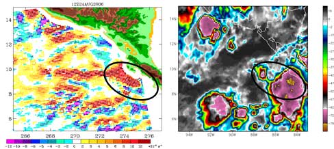
- Detection of tropical disturbances, and development of a better understanding of their development (or non-development) to tropical cyclones
- Evolution of Southern hemisphere storms
- Investigation of the processes involved in the transition of sub-tropical cyclones to tropical cyclones
- Physically-based correction of rain-related problems in scatterometer observations
- Validation of purely in situ based flux products
- Improved surface forcing for ocean modeling activities
Past activities include:
- Validation of scatterometer winds
- Development of objective analysis of daily surface winds
- Physically-based understanding of the link between wind, currents, surface waves, scatterometer observations, and stress (PDF Document)
Contact