
Regionally organized winter (DJF) precipitation anomalies over North America are presented in association with cold and warm phases of the El Niño - Southern Oscillation. Variations in low-level flow from moisture sources and in upper-level dynamic properties are diagnosed for each anomalous precipitation region using DJF composites of upper and lower tropospheric winds, sea-level pressure, divergence, and vorticity advection. Variance analysis determines which precipitation and circulation patterns are robust and evaluates the predictability of the extreme phase composites with respect to the climatology.
In cold phases, the Pacific Northwest and the lower Mississippi Valley regions have above normal precipitation totals. The heavier precipitation over the Pacific Northwest is the result of a multi-level onshore flow forced by an amplified Pacific High off the California Coast and a single zonal upper tropospheric jet. In the Lower Mississippi and Tennessee Valleys, the equatorward entrance region of a west-east oriented jet core combines with anomalous positive vorticity advection (PVA) and a convergent low-level flow off the Gulf of Mexico, resulting in heavier precipitation. Drier than normal conditions occur in coastal Alaska and California due to negative vorticity advection anomalies aloft, low-level divergence, and weaker onshore flow. The increased precipitation over the southern Mississippi Valley and the Pacific Northwest, and the drier conditions over Florida, are statistically robust.
During warm phases, more precipitation occurs in the coastal regions of Alaska, California, and the Gulf of Mexico while drier conditions persist over the Pacific Northwest. Alaskan precipitation is enhanced by strong, convergent, onshore flow associated with a deeper Aleutian Low, upper level PVA, and the northern branch of a split jet pattern. A strong southern subtropical branch of the split jet provides dynamic support for uplift of moisture along the Gulf Coast. The drier conditions in the Pacific Northwest and the wet conditions in Texas and Florida are predictable relative to the climatology and statistically robust.
Extratropical impacts of the El Niño - Southern Oscillation (ENSO) phenomenon are now widely accepted (Glantz 1996). In the atmosphere, ENSO has been related to temperature and precipitation anomalies which, in extreme cases, can lead to disastrous flooding or droughts. The focus herein is to diagnose and associate changes in winter mean lower and upper tropospheric circulations to known ENSO related precipitation anomalies over North America. Essential elements for the formation of extratropical precipitation include moisture, normally transported by low-level circulations, and upper-level dynamics which modify vertical motions. Our primary objective is to identify regionally coherent changes in mean lower and upper tropospheric circulations and to discuss how these flow changes will impact moisture availability and dynamic lift over regions of anomalous winter precipitation. In addition, variance analysis determines which precipitation and circulation patterns are robust and evaluates the predictability of the extreme phase composites with respect to the climatology.
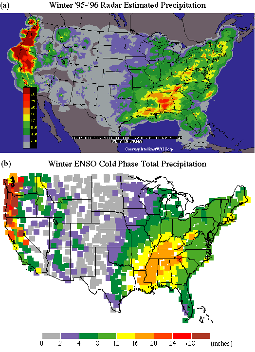
Spatially coherent patterns of anomalous precipitation occur during winters when the equatorial Pacific waters are colder or warmer than the climatological conditions. In some winters this leads to record rainfall or drought. As an example, during the winter of 1995-1996, record wet conditions occurred in the Pacific Northwest and record snows fell over much of the eastern U.S. (Le Comte 1997). These heavy precipitation patterns are apparent in the doppler estimated total rainfall for the 1995-1996 winter (Fig. 1a). The record rainfall in the Pacific Northwest, precipitation totals more than 10 inches above normal in eastern Tennessee, and decreased precipitation in the southwest and Alaska (Le Comte 1997) are consistent with the anomalous precipitation patterns during ENSO cold phase winters (Fig. 2a). Comparing the radar totals (Fig. 1a) to the composite total precipitation for cold phase winters (Fig 1b) reveals striking resemblances in both location and magnitude of the precipitation.
ENSO-related precipitation anomalies have received much attention in published works. In a global context, Ropelewski and Halpert (1996) and Kiladis and Diaz (1989) focused on statistical relationships between an index of the Southern Oscillation and precipitation measurements. Both Ropelewski and Halpert (1996) and Kiladis and Diaz (1989) agreed that, over North America, the ENSO warm phase results in heavier precipitation along the Gulf Coast. Heavier Gulf Coast precipitation was also noted in the North American precipitation work of Green (1996) and Sittel (1994a,b). Furthermore, Green (1996) and Sittel (1994a,b) showed a drying over Florida and the southeastern U.S. during an ENSO cold phase. A drying along the Gulf Coast was noted by Ropelewski and Halpert (1996), but the structure varied from the pattern identified by Green (1996) and Sittel (1994b). Wetter conditions during ENSO cold phases in the Tennessee Valley are noted by Green (1996) and Sittel (1994b), although this wet pattern was not discussed in the other works. Along the Pacific Coast of North America, Green (1996) found dry (wet) conditions in coastal Alaska, wet (dry) conditions in the Pacific Northwest, and dry (wet) conditions in coastal California during a cold (warm) phase. This opposition of precipitation patterns along the Pacific Coast was also described by Yarnal and Diaz (1986). In a regional study, Shabbar et al. (1997) found the wet (dry) anomalies of the Pacific Northwest to extend inland over southern Canada as far as the western Great Lakes. Although our precipitation analysis does not resolve this inland extension, the results of Shabbar et al. (1997) are consistent with our diagnostic results. Overall, these previous articles detailed regions of coherent ENSO/precipitation signals over North America, although not all the signals were evident in each individual work. With the exception of Yarnal and Diaz (1986) and Shabbar et al. (1997), these authors used statistical techniques and rarely presented direct analysis of circulation changes responsible for the precipitation anomalies.
Herein we focus on the circulation changes over all of North America. Changes in seasonal mean circulations are instrumental in the development of large spatial scale, seasonal precipitation anomalies. Regions of spatially coherent anomalous winter precipitation are presented in association with the extreme (cold and warm) ENSO phases. For each regionally organized precipitation anomaly, variations in the winter mean low-level flow are presented and implications for moisture transport are discussed. Winter mean upper-level circulation features are diagnosed as either enhancing or suppressing vertical motion, resulting in anomalous precipitation.
The precipitation, low-level flow, and upper-level circulation anomalies for each phase of ENSO are determined by categorizing winters as occurring during either cold, warm, or neutral ENSO years. Composite extreme phase winters and anomalies from the neutral winters are presented for sea-level pressure (SLP), winds, and derived divergence and relative vorticity advection. Relationships between these mean-flow composites and anomalies and the extreme ENSO phase winter precipitation anomalies are discussed. Variance analysis techniques are used to identify regions where the composite patterns are robust and to determine the relative predictability of circulation changes in cold and warm phases.
The primary goal of our work is to diagnose changes in mean-flow winter circulations associated with ENSO phases and to relate the changes to anomalous winter precipitation. A secondary objective is to validate the composite patterns and assess the relative predictability of changes in the winter mean circulations. These objectives are reached using winter composite analysis of precipitation, SLP, and wind data and a variance analysis using ratios of root mean square differences. Our focus is squarely on variations in mean quantities, an essential first step in understanding complex seasonal interactions.
The authors acknowledge that extratropical precipitation is a phenomenon directly related to transient features on the synoptic time scale. For a limited number of ENSO cycles, the role of transient features was investigated by May and Bengtsson (1996) over the Northern Hemisphere. Furthermore, in a case study of the 1986-1989 ENSO cycle, Chen et al. (1996) discussed the role of eddies in maintaining and modulating the upper tropospheric split jet over the South Pacific. Both these studies show synoptic-scale transients to be linked to the mean-flow jet stream (the storm track); however, some caution must be exercised, as these results are from a limited sample of ENSO events. In this article we emphasize changes in the mean flow characteristics over a long (30 - 40) year record where only operational (and often subjective) analyses are available. Although transient features are transported by the mean flow and contribute to anomalies at seasonal time scales, we are reluctant to directly analyze transients using the current data set, preferring to complete transient studies at a future date using the National Center for Environmental Prediction/National Center for Atmospheric Research (NCEP/NCAR) 40-year reanalysis data (Kalnay et al. 1996).
Identification of winter mean dynamic features and circulations during ENSO winters is accomplished using five by five degree monthly mean wind and pressure analyses from NCAR. According to W. Spangler (1997, personal communication) these analyses were created from operational grids provided by the U.S. Navy, U.S. Air Force, NCEP, and others. Prior to 1960, the monthly analyses were created from digitized versions of subjectively analyzed maps. Objective techniques were used in later years. The NCAR analyses cover the Northern Hemisphere from 20°N to the North Pole and are analyzed herein for a North American grid from 20°N to 70°N and 35°W to 155°W. Variables used include SLP and wind (u,v) data at the standard levels.
In addition to the wind and SLP data, divergence at 850 hPa and 500 hPa relative vorticity advection are derived from the u,v wind grids. The divergence and vertical component of the relative vorticity were computed using a finite difference technique in spherical coordinates (Holton 1992). The relative vorticity is calculated at the center of each five-degree grid box, allowing the advection of relative vorticity to be computed at the original wind grid points. Divergence was directly calculated at the wind grid points. Use of a finite difference technique prevents the divergence and relative vorticity advection from being calculated along 20°N; thus these fields start at 25°N.
Precipitation anomalies are diagnosed over North America from the Global Historical Climatology Network (GHCN) total monthly precipitation data (Vose et al. 1992). From this data set, a total of 1812 stations with less than 20% missing data are used to create winter average precipitation over North America for the years from 1947 to 1986. The station density is greatest over the lower 48 states of the U. S. and southern Canada. Fewer stations are available in Mexico, Alaska, and northern Canada.
The GHCN precipitation data and NCAR analyses are categorized by winters that occur in either a cold, warm, or neutral ENSO year. ENSO years are determined using the Japanese Meteorological Agency (JMA) sea surface temperature (SST) index (Shriver and O'Brien 1995). The JMA SST index is a five-month running mean of SST anomalies over the equatorial Pacific Ocean from 4°N to 4°S and 150°W to 90°W. A cold phase year is defined as a period from October through September of the following year, where the JMA SST index is less than -0.5°C for six consecutive months beginning prior to October and including October, November, and December (Shriver and O'Brien 1995). Warm phase years have the same criterion, except the JMA SST index must exceed +0.5°C. All years not classified as warm or cold phases are considered neutral years. Table 1 lists the cold, warm, and neutral years from 1947 through 1993. ENSO winters are defined as a subset of the ENSO year, namely a three-month season consisting of December, January, and February (DJF) (e.g., the 1968 ENSO winter contains D'68 , J'69 , F'69). Due to varying record length, the precipitation, SLP, and wind data cover a different number of cold, warm, and neutral ENSO winters (Table 2).
| Table 1: Cold, warm, and neutral phase years based on the JMA SST index. Each year marks the beginning of the ENSO year (e.g., 1947 = October 1947 through September 1948). | ||
| Cold | Warm | Neutral |
| 1947 | 1951 | 1950 |
| 1948 | 1957 | 1952 |
| 1949 | 1963 | 1953 |
| 1954 | 1965 | 1958 |
| 1955 | 1969 | 1959 |
| 1956 | 1972 | 1960 |
| 1964 | 1976 | 1961 |
| 1967 | 1982 | 1962 |
| 1970 | 1986 | 1966 |
| 1971 | 1987 | 1968 |
| 1973 | 1991 | 1974 |
| 1975 | 1977 | |
| 1988 | 1978 | |
| 1979 | ||
| 1980 | ||
| 1981 | ||
| 1983 | ||
| 1984 | ||
| 1985 | ||
| 1989 | ||
| 1990 | ||
| 1992 | ||
| 1993 | ||
Table 1: Cold, warm, and neutral phase years based on the JMA
SST index. Each year marks the beginning of the ENSO year (e.g., 1947 =
October 1947 through September 1948).
The NCAR analyses, though coarse in grid resolution, were chosen over more recent reanalysis data primarily based on the authors' intention to diagnose ENSO phase circulation changes over a minimum period of 30 years. The reanalyses (e.g. from NCEP) are desirable; however, at this writing they were available only back to 1973. This would allow only 3 cold and 6 warm ENSO events (Table 1) to be included in the composites as opposed to a maximum of 13 cold and 11 warm event when using the NCAR data (Table 2). The small sample of events included in the NCEP reanalysis would provide a less desirable sample of ENSO phases for the creation of composites and statistical testing.
Three-month winter (DJF) means are created for the precipitation, wind, SLP, divergence, and vorticity advection and composites are constructed for each ENSO phase. The ENSO winter composites are created by summing the DJF means for each phase and dividing the sum by the number of events in each phase (Table 2). In addition to the cold, warm, and neutral phase composites, an all-year winter composite (climatology) is created. The DJF composites are calculated at each station for the precipitation data and each grid point for the NCAR analyses.
| Table 2: Available years of GHCN precipitation and NCAR wind and sea-level pressure data. For each dataset, the numbers of cold, warm, and neutral phase winters are listed. | ||||
| ENSO winters covered by data | ||||
| Variable | Years | Cold | Warm | Neutral |
| Precipitation | 1947 - 1986 | 12 | 9 | 19 |
| Sea-level pressure | 1947 - 1993 | 13 | 11 | 23 |
| Wind (850,300 hPa) | 1963 - 1993 | 7 | 8* | 15 |
| *no wind data available for the 1969 winter | ||||
Table 2: Available years of GHCN precipitation and NCAR wind and
sea-level pressure data. For each dataset, the numbers of cold, warm, and
neutral phase winters are listed.
Changes between cold, warm, and neutral phases are identified by creating DJF composite anomalies: cold phase minus neutral phase and warm phase minus neutral phase. Subtraction of the neutral phase winter composite, instead of the winter climatology, is used because the winter climatology includes the cold and warm phase winters. A clear separation of the cold, warm, and neutral winters is preferred for identifying ENSO signals.
A test to determine whether the composite pattern is robust is essential, and a measure of the predictability is desirable. These tests are completed using a ratio of root mean square (RMS) differences for each grid point. This ratio is created by dividing the RMS difference for each extreme phase composite by the RMS difference for the climatology. These RMS ratios are a measure of the variability during a cold or warm phase relative to the climatological variability. For the winds, the speed dependence of the RMS ratio is removed by computing the RMS differences as a percentage.
A composite pattern is robust (not robust) when the RMS ratios are significantly less than (greater than) unity. Statistical significance is determined using a one-sided F-distribution test (Bhattacharyya and Johnson 1977). Two hypotheses were tested to determine if the RMS ratio was either significantly greater than unity (extreme phase more variable than climatology) or significantly less than unity (extreme phase less variable than climatology). The results of these statistical tests are presented for the cold and warm phase RMS ratios of precipitation, SLP, and winds in Table 3.
| RMS | Precipitation | Sea Level Pressure | 850 & 300 hPa winds ratio | ||||
| Cold | Warm | Cold | Warm | Cold | Warm | ||
| 0.4 | 95 | 95 | 93 | 95 | 95 | 95 | |
| 0.5 | 95 | 95 | 95 | 95 | 95 | 93 | |
| 0.6 | 95 | 90 | 95 | 95 | - | 90 | |
| 0.7 | 90 | - | 90 | - | - | - | |
| 0.8 | - | - | - | - | - | - | |
| 1.2 | - | - | - | - | - | - | |
| 1.3 | - | - | - | - | - | - | |
| 1.4 | 90 | 90 | 90 | 90 | - | - | |
| 1.5 | 95 | 90 | 93 | 95 | 90 | 90 | |
| 1.6 | 95 | 95 | 95 | 95 | 95 | 95 | |
Table 3: Significance level for the precipitation, sea-level pressure, and
wind RMS ratios. Based on a one-sided F-distribution test (Bhattacharyya
and Johnson 1977).
Predictability can be assessed relative to the climatology using the RMS ratios or in absolute terms by analyzing the variance of the extreme phase values. The values of the extreme phase are more (less) predictable relative to the climatology when the RMS ratio is less than (greater than) unity. In absolute terms, the predictability only depends on the variance of the composite values. When the variance of the composite values is small, the composite is inherently predictable due to small deviations from the mean. Within this manuscript, extreme phase predictability is evaluated relative to the climatology. Therefore, the robustness of the composite pattern and the relative predictability can both be assessed using the RMS ratios.
The DJF composite anomalies for the cold and warm phases show distinct regions of more wet (green) or dry (red) conditions (Fig. 2). During the cold phase (Fig 2a), a dry-wet-dry pattern occurs along the Pacific coast, with dry anomalies ranging from -3 cm in Alaska to greater than -4 cm in California, and with wet anomalies of greater than +4 cm in the Pacific Northwest. Over the eastern U.S. a large region of heavier precipitation occurs, with maximum anomalies of greater than +4 cm in the Tennessee Valley. Slightly drier than neutral phase conditions (-2 cm) exist over most of Florida and the coastal Carolinas.
During the warm phase (Fig. 2b), anomalies of opposite sign exist along the Pacific Coast; however, the magnitudes are not opposite. The dry conditions in coastal Alaska during the cold phase are replaced by very heavy rainfall (up to +6 cm at one station) in the warm phase. The Pacific Northwest is dry with the exception of Vancouver Island, and northern California is wet, with anomalies greater than +4 cm. In our analysis, extreme southern California is slightly drier during a warm phase. Over the Gulf Coast and Florida the warm phase brings heavy rains (Kiladis and Diaz 1989; Sittel 1994a; Ropelewski and Halpert 1996); thus, Florida has opposite precipitation anomalies than the cold phase when the state is drier than neutral years. Over Louisiana and Mississippi, above neutral rainfall occurs in both cold and warm phases. Slightly drier conditions replace the +2 cm wet conditions of the cold phase over Indiana.
RMS ratios (Fig. 2c,d) for the precipitation composites are used to identify robust patterns and to assess the relative (to the climatology) predictability of the extreme phase values. For a cold phase, positive precipitation anomalies over the Pacific Northwest, Mississippi, and northern Louisiana are robust (Fig. 2c), with RMS ratios less than 0.6 (green) being significant at the 95% level. As the variability in these regions is lower during a cold phase, the wet anomalies in the Pacific Northwest and western Gulf states is more predictable relative to the climatology. In contrast, the large positive precipitation anomalies over Tennessee and Kentucky, are not statistically robust with RMS ratios near 1.0 (gray). The drier conditions (negative anomalies) over Florida and southern California are robust, but with statistical significance at the 90% level. Meanwhile the drier conditions in northern California are not robust, with RMS ratios near 1.3 (i.e., cold phase has 30% more variance than the climatology). With respect to the climatology, the drier conditions in Florida and southern California have enhanced predictability. In summary, relatively predictable (with respect to the climatology) cold phase precipitation anomalies occur over the Pacific Northwest and the southern Mississippi Valley (wetter) and southern California and Florida (drier).
During warm phase winters (Fig. 2d), most stations in Washington have significant (90% level) RMS ratios (< 0.6), indicating that the dry conditions of the Pacific Northwest are relatively predictable and robust. The dry conditions in southern California are also statistically robust and show better predictability relative to the climatological values. Over the remainder of California, the wet anomalies show a degree of relative predictability (RMS ratios between 0.6 and 0.8), but the pattern is not robust at the 90% level. In the region of heavy Gulf Coast precipitation, the anomaly pattern in both Florida and Texas is robust with RMS ratios less than 0.6 (90% level). However, the central Gulf Coast has RMS ratios above 1.2 (orange), which show the wet conditions in this region to be more variable than the climatology and not robust. The implication is that, relative to the climatological precipitation, warm phase winter precipitation is more variable over Louisiana than over Texas and Florida. To summarize, predictable (relative to the climatology) warm phase precipitation anomalies occur over Florida and coastal Texas (wetter) and the Pacific Northwest and southern California (drier).
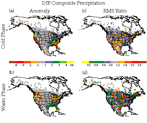
Fig.
2. Winter precipitation composite anomalies for the (a) cold and (b) warm
phase created from Global Historical Climatology Network data.
Precipitation anomalies are plotted in centimeters with magnitudes
displayed in color bar. Adapted from Green (1 996). In addition, root mean
squared (RMS) ratios are presented for the (c) cold and (d) warm phase
winter precipitation composites. RMS ratios are unitless with magnitudes
displayed in color bar. See Table 3 for
statistical significance levels.
Throughout the next section, the authors will identify mean circulation features associated with the precipitation anomalies identified in Fig. 2. Our primary interest is identifying the source of the reversal of the precipitation pattern along the Pacific coast from a cold phase to a warm phase, and the shift from heavy precipitation along the Gulf Coast in a warm phase to heavy precipitation in the Tennessee Valley and dry conditions over Florida in the cold phase. As a secondary topic, robust features of the mean circulation are identified and the predictability with respect to the climatological conditions is discussed.
Precipitation, anomalous or otherwise, requires two ingredients: a moisture source and a force to lift the moisture to the condensation level. These are not the only parameters involved, but they are essential. The next sections identify mean flow changes over North America during cold and warm phases and discuss how these changes affect moisture supply and vertical motion. Due to the lack of a moisture variable in the NCAR analyses, the authors identify variations in the low level winds and divergence and infer changes in moisture transport into North America from the Pacific Ocean and the Gulf of Mexico. Analysis begins near the surface moisture source and extends to the middle and upper troposphere.
a. Flow affecting moisture transport
1) SEA-LEVEL PRESSURE
Variations in SLP will alter the low-level wind flow and lead to a subsequent modification of moisture transport. Four climatological SLP centers are of interest to the mean surface flow into North America: the Aleutian and Icelandic Lows and the Pacific and Bermuda Highs. The cold phase winter SLP pattern over the eastern Pacific (Fig. 3a) is dominated by a strong Pacific High and a weak Aleutian Low. In the warm phase winter composite (Fig. 3b), an opposite pattern occurs, with a deep Aleutian Low and a small, weak Pacific High. Detailed discussion of the oscillation in the strength of the eastern Pacific SLP centers was presented by Emery and Hamilton (1985). This oscillation is clearly shown as a reversal from positive SLP anomalies in the cold phase (Fig. 3c) to negative anomalies during the warm phase (Fig. 3d). Over the Atlantic, positive anomalies along the East Coast indicate a westward elongation of the Bermuda High during the cold phase (Fig. 3a). In a warm phase winter, negative pressure anomalies result in a weaker Bermuda High that remains well to the east of the U.S. coast (Fig. 3b). In the North Atlantic, the Icelandic Low shows only slight variation in our analysis, being deeper in the cold phase. Also worth noting is the 1020 hPa high over the Yukon that is present during the cold phase and weakens during the warm phase. The impact of SLP variations on low-level winds will be discussed in the next section.
RMS ratios allow an assessment of the robustness of the SLP patterns and the relative predictability of the pressure values. The cold phase composite pattern is statistically robust (90% level) over portions of the eastern Pacific, northwest Canada, and Quebec where RMS ratios are less than 0.7 (Fig. 3c). Relative to the climatological winter SLP, the stronger Pacific High and weaker Aleutian Low show enhanced predictability during a cold phase winter. In contrast, the strengthening of high pressure over the southeastern U.S. is not statistically robust and RMS ratios (greater than unity but not exceeding 1.3) reveal an increase in cold phase variability with respect to the climatology. During the warm phase winters (Fig. 3d), no statistically robust changes occur in the primary SLP centers (e.g., Aleutian Low, Icelandic Low, Bermuda High, and Pacific High).
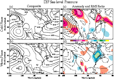
Fig.
3. Winter sea-level pressure composites for the (a) cold and (b) warm
phase and composite anomalies for the (c) cold and (d) warm phase. Color
analysis of RMS ratios for the (c) cold and (d) warm phase underlie the
sea-level pressure anomalies. Composite pressure contour interval is 4 hPa
with an intermediate contour dashed at 1018 and 1022 hPa for added clarity
in high pressure regions. Pressure anomaly contour interval is 1 hPa with
a dashed zero line and dotted contours for negative values. RMS ratios are
unitless with magnitudes displayed in color bar. See Table 3 for statistical significance
levels.
In summary, the Pacific centers alternate strength, with a weak (strong) Aleutian Low and a strong (weak) Pacific High in the cold (warm) phase. For a cold phase the increased SLP over the eastern Pacific is robust and, relative to the climatology, predictable; however, the same statistical analysis does not show relative predictability for the decreased SLP during a warm phase. In the Atlantic, both SLP centers become stronger in a cold phase winter and weaker in a warm. A westward elongation of the Bermuda High is noted in a cold phase, but with RMS ratios greater than unity, an increased variability of the Bermuda High is expected. All SLP changes shown for the Pacific and Atlantic are consistent with those found by van Loon and Madden (1981).
2) LOW-LEVEL WINDS
The changes in SLP patterns in cold and warm phase winters (Fig. 3) are associated with alterations in the low-level wind flow. Assuming moisture is advected from the oceans by the low-level winds, the changes in the winds will influence the moisture supply for precipitation. Ideally we would use in situ moisture data; however, quality moisture data for all of North America is hard to locate for a 30-year record. Therefore we analyzed the mean wind flow at 850 hPa to identify regions of cross-coast flow and computed the 850 hPa divergence fields to locate regions where moisture may be converging.
The low-level wind composite is dominated by a single core of westerlies crossing North America in both phases (Fig. 4); however, changes in the orientation of the wind maxima modify moisture transport to the continent. The location where the eastern Pacific low-level wind maximum crosses the coast clearly shifts from the Pacific Northwest in the cold phase winter (Fig. 4a) to southern Alaska in the warm phase (Fig. 4b). This change in orientation occurs in response to the deeper Aleutian Low in the warm phase and the stronger Pacific High in the cold phase.
Changes in the orientation of the eastern Pacific low-level wind maximum are accompanied by variation in the strength of the onshore flow. During a cold phase, westerly wind speeds are 15% to 30% stronger than neutral years over the Pacific Northwest (Fig 4c). This increase in the westerlies occurs on the north side of an anomalous anticyclonic circulation at 40°N, 145°W. This anticyclone also supports stronger (than warm phase) winds blowing parallel to the shore of southern California (Fig. 4a), thus limiting the moisture flow into California. Along the Alaskan coast, an anomalous northerly offshore flow also occurs at 850 (Fig. 4c) and 700 hPa (not shown) in association with the weaker Aleutian Low and stronger high in the Yukon. This results in weaker onshore flow in the composite and less moisture for Alaskan precipitation. During the warm phase, the low-level flow over the eastern Pacific is dominated by the strong Aleutian Low (Fig. 3b), resulting in a 45% increase in south and southeasterly flow along most of the Alaskan coast (Fig 4d). Consequently, an increase in moisture flowing into Alaska is expected. Over southern California, wind speeds are 15% weaker and the mean wind component (Fig. 4b) is still primarily along the shoreline. With a mean flow along the coastline, onshore flow of moisture should be limited in southern California during a warm phase winter.
A main source of moisture for precipitation in the eastern U.S. is the Gulf of Mexico. During a cold phase, the stronger, eastward elongated Bermuda High supports an anticyclonic anomaly east of Cape Hatteras, North Carolina (Fig 4c). The anticyclone increases easterly flow in the subtropical Atlantic and drives a 45% increase in the southerly flow over the western Gulf of Mexico. In contrast, during a warm phase the Bermuda High shifts eastward, resulting in a broad southwesterly flow over the entire Gulf of Mexico (Fig. 4b). The largest increase in the southwesterlies (45%) occurs over extreme southern Florida (Fig. 4d). From these patterns we conclude that moisture supply for precipitation is concentrated over the western Gulf states during a cold phase, while a warm phase brings a broader inflow of moisture to the entire Gulf coast.
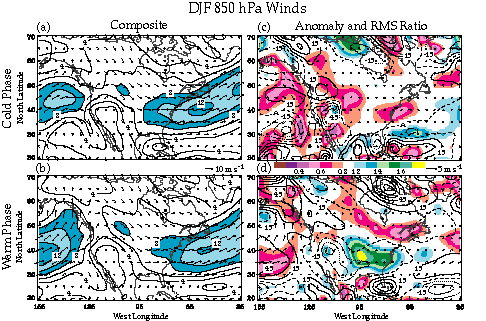
Analysis of 850 hPa divergence reveals where the onshore flows are converging, thus supporting precipitation. Convergent flow occurs over the Pacific Northwest and western Gulf Coast states in the cold phase (Fig. 5a) and from north coastal California to Alaska in the warm phase (Fig. 5b). These are all regions that show an increase in precipitation, with the exception of the Pacific Northwest in the warm phase. Divergent flow occurs over Alaska and California in the cold phase (Fig. 5a) and southern California in the warm phase (Fig. 5b). Drier than neutral conditions exist in these regions. Clearly the relationship of convergence (divergence) resulting in more (less) precipitation does not apply to all regions where ENSO alters precipitation (i.e., Gulf Coast in warm phase). It is in these regions that smaller spatial and temporal scale features likely play a key role.
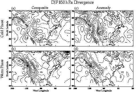
To summarize, variations in low-level flow will shift the focus of Pacific moisture transport from the Pacific Northwest in cold phase winters to a broad region of the Alaskan and Canadian Pacific coasts in warm phase winters. During a cold phase, weaker onshore flow in Alaska, as evidenced by divergent, northerly anomalies (Figs. 4c and 5c), will result in less moisture being available for precipitation. Over southern California in the cold phase, a stronger along-shore flow and low-level divergence limit moisture transport inland. Finally, along the Gulf of Mexico coast, low-level convergence (Figs. 5a,c) is limited to the western Gulf during a cold phase, implying that moisture transport is concentrated on the western return flow. A broad southwesterly flow occurs over the entire Gulf during a warm phase winter, with the greatest increase in southern Florida.
Analysis of the ratio of extreme phase percentage RMS difference to the climatological percentage RMS difference provides a measure of the relative predictability and the robustness of the 850 hPa wind composites. Over the eastern Pacific during a cold phase, regions with RMS ratios less than 0.7 tend to follow the circulations around the Aleutian Low and Pacific High (Fig. 4c). Robust wind patterns (95% level) occur within the northerly anomalies over the Alaskan coast and the northwesterly mean flow off the coast of California (though the anomalies are small in this region). Relative to the climatological winds, RMS ratios show an enhanced predictability of the westerly winds focused on the Pacific Northwest during a cold phase (RMS ratios < 0.6); however, the pattern is not statistically robust at the 90% level. During a warm phase (Fig 4d), the westerlies south of the Aleutian Low are robust (90% level) and are more predictable relative to the climatology. The relative predictability is also enhanced for the onshore flow along the Alaskan coast where RMS ratios are less that 0.7, although the pattern is not robust at the 90% level.
Over the Gulf of Mexico (Fig. 4c), RMS ratios with values up to 1.3 show the cold phase southerly flow to be more variable than climatology. In contrast, the easterly flow on the south side of the Atlantic ridge is more robust (with some values significant at the 95% level). From the pattern of RMS ratios we conclude that an increase in the low-level easterlies over the Caribbean is likely during a cold phase; however, the southerly moist flow off the western Gulf will display event-to event variability. During a warm phase (Fig. 4d), the pattern of southwesterly flow is statistically robust (90% level) only in the western Gulf of Mexico where RMS ratios are less than 0.6. In the region of large anomalies over southern Florida, the pattern is not statistically robust and the variability is similar to the climatology (RMS ratios near 1.0).
The low-level wind variability over the western Gulf of Mexico leads to a contradiction. During the cold phase the southerly flow is stronger, but more variable than climatology (Fig 4c), while cold phase precipitation is heavier (Fig. 2a) and less variable (Fig. 2c) along the coast. In the warm phase, the southwesterly flow shows lower variability south of Louisiana (Fig. 4d), where the heavy precipitation (Fig. 2b) has increased variability (Fig. 2d). Therefore, the composite low-level flow alone is not sufficient to diagnose precipitation anomalies in this region.
b. Sources of dynamic lift
Identifying the cause of anomalous precipitation requires, in addition to understanding the low-level flow and its influence on moisture transport, an examination of upper-level dynamic lift. Variations in the upper-level winds are key to altering the dynamic lift in a way that either enhances or suppresses precipitation. Topographic and thermal forcing are noted as other sources of lift, but they are not explicitly detailed.
1) JET STREAM WINDS
Winds at the jet stream level play a role in the vertical motion of the atmosphere. The concept of direct and indirect circulations associated with the entrance and exit regions of a core of upper level winds was proposed by Namias and Clapp (1949) and a recent discussion is provided by Uccellini (1990). For a zonally oriented jet in the northern hemisphere, these authors show that rising (sinking) motion occurs beneath the equatorward (poleward) entrance quadrant and the poleward (equatorward) exit quadrant of a core of stronger winds. From analysis of the 300 hPa jet stream for cold and warm phase winters, we identify shifts in the uplift and subsidence quadrants of the composite jet cores.
The 300 hPa winds exhibit a shift from a single, zonal mean jet stream
in the cold phase winter (Fig. 6a) to a more
meridional split jet with a dominant southern branch in a warm phase (Fig.
6b). The equatorward shift of the dominant southern branch of the mean jet
has been related to the anomalous warming of the equatorial Pacific waters
(Philander 1990). To date, the direct impact of cold equatorial SST
anomalies on the Pacific jet is not published. However, the shift from
stronger (weaker) mid-latitude westerlies and weaker (stronger) westerlies
in the subtropics during a cold (warm) phase was discussed by van Loon and
Rogers (1981).
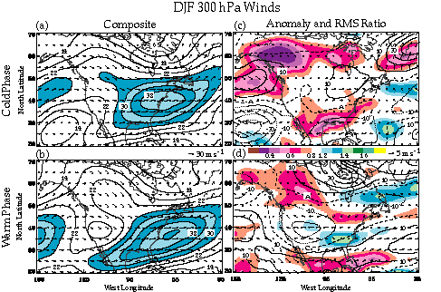
The shift from a split mean jet in the warm phase winter to a single zonal mean jet during a cold phase alters the upper-level dynamics by changing the orientation and strength of the mean jet cores. For the jet core over the eastern U.S., the orientation shifts from southwest to northeast in the warm phase to a west-east orientation in the cold phase. As a result, the uplift region associated with the equatorward entrance quadrant of the jet moves northward in the cold phase, shifting upper level support for heavy precipitation from the Gulf Coast inland to the Tennessee Valley.
The anomalous wind flow during a cold phase supports an anticyclonic anomaly over Kentucky (Fig. 6c), indicating an increase in the meridional circulations of the jet core. This 300 hPa anomalous anticyclone is the upper tropospheric reflection of the westward tilting ridge found in the 850 hPa anomaly field off Cape Hatteras (Fig 4c). In addition to enhancing the circulation in the entrance region of the jet core, this multi-level anticyclone provides a conduit for moisture flowing northward from the Gulf on the west side of the anomaly center. When this southerly moisture flow combines with the dynamic lift of the equatorward jet entrance quadrant, increased precipitation occurs over the southern Mississippi and Tennessee Valleys.
During a warm phase (Fig. 6d), the split jet results in an anticyclonic anomaly in western Canada and a cyclonic anomaly in northern Mexico. These anomaly circulations, meridionally stacked along 108°W, maintain the southwesterly flow over the Gulf of Mexico and an easterly flow anomaly over much of the continental United States. The southwesterly flow over the Gulf extends to the surface and provides ample onshore flow for precipitation in a region where uplift is supported by the equatorward entrance region of the jet core (Fig 6b).
A second 300 hPa jet core remains offshore over the eastern Pacific in the cold (Fig. 6a) and warm (Fig. 6b) phases. The single cold phase jet is supported by the upper atmospheric portion of a vertically stacked anticyclonic anomaly off the California Coast (Fig 6c). This anticyclone enhances the westerly flow into the Pacific Northwest, which in turn transports more synoptic-scale transients into the Pacific Northwest coast (May and Bengtsson 1996). These transients interact with a convergent low-level onshore flow, resulting in heavier precipitation. During the warm phase, the Pacific jet is much stronger and the enhanced flow should increase upward motion in the poleward exit region, thus deepening the Aleutian Low. At approximately 140°W the Pacific jet splits, sending some energy to Alaska and the remainder south toward Mexico. Although the dominant storm track follows the southern branch of the split jet (May and Bengtsson 1996), the longitude where the split occurs and the relative strength of the northern and southern jet branches will influence the amount of precipitation over the West Coast, especially California, during a warm phase winter.
Statistically robust patterns (90% level) in the warm phase 300 hPa winds are found along the northern jet over Canada and the subtropical jet over Mexico and the Gulf. These low RMS ratios (Fig. 6d) indicate that the wind values are less variable in these regions during the warm phase; thus, relative to the climatological winds, there is an enhancement in the predictability of the winds. The lack of statistically significant RMS ratios over the eastern Pacific reveals no significant change in wind variability with respect to the climatology. We conclude from the pattern of RMS ratios that, relative to the climatological mean winds, the occurrence of a split 300 hPa jet during a warm phase is predictable, while the position of the split varies from one warm phase to the next. The higher degree of variability where the jet splits (relative to the variability in the split branches over the continent) results in increased variability in the precipitation pattern over California.
The cold phase 300 hPa pattern (Fig. 6c) shows statistically robust (95% level) RMS ratios (< 0.5) in the westerly anomalies south of Alaska and the easterly anomalies along the western Gulf coast. Relative to the climatological winds, the easterly anomalies along the Gulf coast are predictable and an indicator of the northward shift of the equatorward entrance quadrant of the jet core. South of Alaska, the decreased variability in the cold phase winds enhances the predictability of westerly anomalies with respect to the climatology. As a result, we conclude that the single jet will be focused on the Pacific Northwest during most cold phases.
In summary, the cold phase winter composite jet stream pattern is dominated by single zonal jet with two cores. In the west, one jet core focuses cyclones on the Pacific Northwest while a west-east oriented jet core over the East Coast provides a region of enhanced uplift over the Tennessee Valley. The stronger onshore flow in the Pacific northwest and weakened westerlies over the Gulf Coast are robust and, relative to the climatological winds, predictable during cold phase winters. The warm phase composite jet is split, with the lowest variability occurring with the southern, subtropical branch over the Gulf of Mexico and subtropical Atlantic. The southwest to northeast orientation of the subtropical jet shifts the region of uplift from the Tennessee Valley in the cold phase southward to the Gulf Coast.
Meanwhile, the northern split over the eastern Pacific supports a deeper Aleutian Low and onshore flow into Alaska. Finally the location of the split over the Pacific is not statistically robust; thus, storms following the southern split may or may not affect southern California.
2) VORTICITY ADVECTION
Another dynamic quantity used to diagnose vertical motion is vorticity advection. Due to the nature of the mean planetary-scale wave pattern over North America (ridge over west, trough over east), the mean vorticity advection in all phases has positive vorticity advection (PVA) over the Alaskan and East coasts and negative vorticity advection (NVA) over the High Plains. The magnitude of the mean vorticity advection does vary in ENSO extreme phases; therefore, the vorticity advection anomalies (Fig. 7) will be used to diagnose where the mean advection promotes uplift or subsidence.
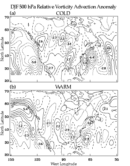
No analysis of the contribution to the vorticity advection by transients was completed. According to Mo and Rasmusson (1993) the contribution of transients to the vorticity balance is small, but not negligible. Therefore, one must consider that the following results may be amplified or diminished by the transient component of the advection.
During the cold phase (Fig. 7a), two winter mean PVA anomalies can be associated with above neutral precipitation. The first promotes uplift over the Pacific Northwest and, in conjunction with a convergent moist flow off the Pacific at low levels, may enhance precipitation. The second stronger PVA anomaly occurs over the Mississippi and Ohio Valleys. Here moisture flowing off the Gulf of Mexico, funneling around the anomalous anticyclone at multiple levels, will be lifted, resulting in heavier precipitation.
Negative vorticity advection dominates the eastern Pacific and coastal Alaska, with a maximum value of -5.8 x 10⁻⁵ m s-2 just west of California. This broad region of NVA promotes subsidence, as evidenced by the vertically stacked anticyclone off the California coast. This subsidence will aid the suppression of precipitation in Alaska and California.
Vorticity advection during the warm phase (Fig. 7b) is dominated by PVA anomalies along the Canadian Pacific and Alaskan coasts. A broad region of 5 x 10⁻⁵ m s-2 is located along most of the Alaskan coast. This PVA anomaly promotes upward motion in the region, and when combined with the low-level moisture inflow from the Aleutian Low, may enhance precipitation. Over the rest of the continent during a warm phase, alternating regions of PVA and NVA extend from the Alaskan anomaly southeastward to the Atlantic. Clearly the mean vorticity advection does not explain anomalous precipitation over portions of the Gulf Coast and Pacific Northwest and the role of transient circulations may play a key role in these regions.
The authors expect that other factors are responsible for the lack of
significant vorticity advection anomalies in some regions with significant
precipitation anomalies. For example, during the 1997 warm phase winter,
much of the Gulf Coast precipitation has been associated with stationary
fronts and jet streaks in the subtropical jet stream. These streaks may
not have a significant vorticity signature at the 500 hPa level and can
not be resolved by the current analysis. Furthermore, in the mountainous
regions of the West Coast, topographic forcing will enhance or suppress
precipitation on scales that can not be identified with the current analysis.
In conclusion, a direct relationship between time mean vorticity advection
and anomalous precipitation (i.e., mean PVA = wet, mean NVA = dry) during
cold and warm events is not present in all regions. It is interesting to
note that this relationship is more apparent during the cold phase than
the warm, although the reasons are not clear at present. Clearly a better
understanding of transient features at low (e.g. fronts and cyclones) and
upper (jet streaks) levels will improve our understanding of ENSO precipitation
anomalies; however, this analysis is reserved for studies using the 40-year
NCEP/NCAR reanalysis data.
The analysis of mean-flow composites and anomalies provides insight into the mechanisms that produce anomalous precipitation during ENSO winters. Although analysis of transient circulations must be expanded in the future, changes in composite low-level circulations and upper tropospheric dynamic features are identified in association with the anomalous winter precipitation patterns. Variations in lower tropospheric divergence and onshore wind will increase or decrease the moisture supply for precipitation by altering moisture transport from the ocean. Upper tropospheric changes in mean jet streams and vorticity advection modify vertical motions in the atmosphere.
We have identified two regions of enhanced cold phase precipitation: the southern Mississippi/Tennessee Valley and the Pacific Northwest, and three regions where drier conditions occur: coastal Alaska, California, and the coastal Carolinas south to Florida. Relative to the climatology, predictable changes in precipitation occur over the southern Mississippi Valley, the Pacific Northwest, southern California, and Florida. Precipitation is enhanced in the eastern U.S. due to an increased moist flow off the Gulf of Mexico being uplifted by the equatorward entrance of the 300 hPa jet in a region of mean PVA. The moist flow is concentrated in the western Gulf by a westward elongation of the Bermuda High, and the moisture is transported well inland on the west side of a multi-level anomalous anticyclone. During a cold phase, the variability of the winds in the eastern U.S. decreases in the upper troposphere; however, more variability occurs in the low level, onshore flow from event to event. Precipitation is enhanced in the Pacific Northwest by a convergent, low-level onshore flow, mean PVA anomalies, increased synoptic-scale transients, and the exit region of a single zonal 300 hPa jet. The onshore flow at both low and high levels of the troposphere is driven by a westerly wind anomaly on the north side of an amplified and vertically stacked Pacific High off of California.
Over Florida and the coastal Carolinas, drying is in part supported by stronger ridging at the surface and low levels. However, at upper levels the dynamics are weak, with a small NVA anomalies and weaker westerlies, and the role of upper tropospheric winds in suppressing precipitation is not evident in the current analysis. Drier conditions over coastal Alaska result as a weaker onshore low-level flow provides less moisture and an NVA anomaly aloft provides less uplift for precipitation. Over California, along-shore to offshore flow, NVA anomalies, and a persistent surface ridge result in drier conditions.
During a warm phase, enhanced precipitation occurs over the Gulf Coast, Florida, coastal Alaska, and northern coastal California. The strongest drying occurs in the Pacific Northwest with some weaker dry anomalies in southern California. The drier conditions in the Pacific Northwest and southern California are statistically robust and predictable relative to the climatology, as are the wet conditions in Texas and Florida. The dry conditions over the Pacific Northwest are in part due to the lack of dynamics aloft as the Pacific jet splits with the subtropical branch heading south of the region and the polar jet heading north. Moisture is also limited as the low-level winds wrap around the deep Aleutian Low, focusing the strongest onshore flow on the southern coast of Alaska. Over coastal Alaska, the strong onshore flow combines with large mean PVA anomalies and topography to greatly increase precipitation in a warm phase winter.
Heavier precipitation over the Gulf Coast is likely during a warm phase as a broad southwesterly flow is present at low levels, and the dominant southern branch of the jet provides uplift in the poleward entrance quadrant. There is no focal point for the low-level flow on the coast as the Bermuda high is weaker and shifted eastward. The largest increase in 850 hPa southwesterlies occurs over southern Florida, but this flow is not statistically robust. Although a weak PVA exists at 500 hPa, the precipitation is more likely the result of transient disturbances in the subtropical jet stream that are not resolved by the current analysis.
Analysis of winter mean composites and anomalies does not answer all questions concerning anomalous precipitation during ENSO winters. The role of transient systems must be further studied and in situ moisture data needs to be incorporated into the analyses. However, the current study serves the purpose of identifying changes in mean circulations that are associated with anomalous precipitation over North America during extreme ENSO phases.
COAPS receives its base funding from the Physical Oceanography Section of the Office of Naval Research. Additional funding for this research was provided by NOAA's Office of Global Programs. The authors gratefully acknowledge Dr. Mark A. Bourassa for his comments and assistance with the statistical analysis. Furthermore, we thank Dr. David M. Legler and Mr. Alan Davis for their professional support. We also acknowledge Mr. James Stricherz and Ms. Jiraporn Whalley for their assistance in producing the figures and Ms. Kathy Fearon for proofreading the manuscript.