.
Movies
Moving Vector Movies
Climatology Forcing
Approx. 90MB
Surface Salinity
Surface Temperature
Surface Elevation
Sep-Oct 2000 With
QuikSCAT/Eta Winds
Approx. 15MB
WFS Surface Elevation
Lagrangian-Eulerian
Time Surfaces
During Loop Current
Eddy Separation
Visualization by Josh Grant
Approx. 19MB
800m Vertical Displacement
Movies require a player
such as
Quicktime
Publications
Bibliography and Reports
Contact Information
For more information
Contact
Steve Morey
of the Gulf of Mexico
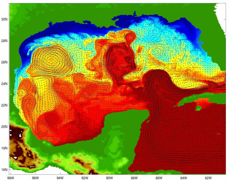
Snapshot of model
sea surface temperature.
Click here for a larger image
Hurricane Dennis Simulations
Tides in the Gulf of Mexico
Researchers at the Center for Ocean - Atmospheric Prediction Studies (COAPS)
are exploring the physical environment of the Gulf of Mexico using a
high-resolution numerical model. The numerical simulation is an application of
the Navy Coastal Ocean Model (NCOM) developed at the U.S. Naval Research
Laboratory. The NCOM is a parallelized three-dimensional primitive equation
ocean model that has been optimized for running on the IBM supercomputers at
FSU. The model solves for the three-dimensional velocity field, temperature,
salinity, and free surface height of the ocean.
The Gulf of Mexico simulation has a horizontal resolution of approximately 5 km
with 60 vertical layers (using a hybrid z-coordinate in the deep ocean and a
terrain-following, or sigma, coordinate in the top 100 m). The domain extends
to the coastline, with a minimum ocean depth of 4 meters. The model employs a
quasi-third-order upwind advection scheme for momentum and scalar fields, which
permits improved simulation of fronts in the ocean.
The Gulf of Mexico simulation is forced by winds, heat flux,
evaporation and precipitation, fresh water inflow from 30 rivers, and flow
through the open boundary in the Caribbean Sea. Different experiments can be
performed by changing various forcing functions, numerical parameters, or the
domain configuration. For example, high-resolution high frequency wind fields
derived from satellite scatterometer data are used to study the ocean's response
to the hurricanes of 1999 and 2000.
The NCOM simulations serve as a virtual laboratory for studying the physics of
the ocean circulation within the Gulf of Mexico. Projects include studies of
the Loop Current and its eddies within the deep ocean, the circulation on the
continental shelves near the coast, the interaction of eddies with the waters of
the continental shelves, and the effects of river discharge on the ocean
environment. Additionally, the model is being used for studies to advance our
understanding of numerical methods, ocean prediction systems, and air-sea
interaction.