Beginning late summer of 1998, a strong La Niña has exerted its influence over Florida's weather patterns. Consistent with typical La Niña climate patterns, Florida saw below normal rainfall from October through April of 1999. In May 1999 the normal summer rains resumed and eased the danger of forest fires and crop damage that the Winter and Spring deficits caused. See the following link for general information on ENSO and climate variability and the current state of the tropical Pacific.
Climate Prediction Center's La Niña Page
The effects of El Niño and La Niña on seasonal U.S. temperature and precipitation patterns have been well documented. A classic study done by COAPS can be found here:
The North American Climate Patterns Associated With The El Niño-Southern Oscillation.
The same techniques are used to create animations of the ENSO related climate temperature and precipitation shifts across the United States.
The above study by Green et al. [1997] indicates that during La Niña years precipitation is below normal for much of Florida for the fall, winter, and spring months. A reanalysis done with more recent data shows that central Florida is particularly hard hit, with 20% less rainfall in each of the three seasons. Continued dry conditions for 6-8 months in a row set the stage for a widespread drought across the state of Florida.
Although Florida received normal to slightly above normal precipitation in January of 1999, the classic La Niña dry pattern became entrenched in Febuary. Maps of rainfall percentages of normal for the U.S. are provided below.
These drier than normal conditions have resulted in drought conditions over much of the state. Here is a map of the current Palmer Drought Severity Index by climate division.
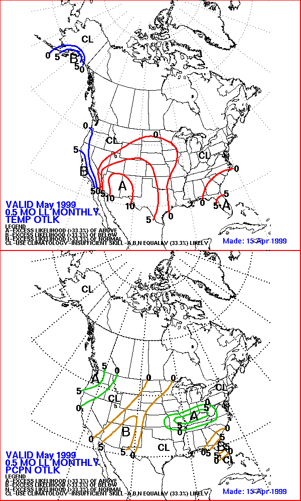
According to the Climate Prediction Center, there will be no quick relief for Florida's drought in the month of May. Their 30-day forcast shows an increased probability of below normal precipitation for central and north Florida. The longer range forecasts indicate an increased probability of above normal precipitation for much of the Southeast with the exception of Florida, with near normal precipitation.
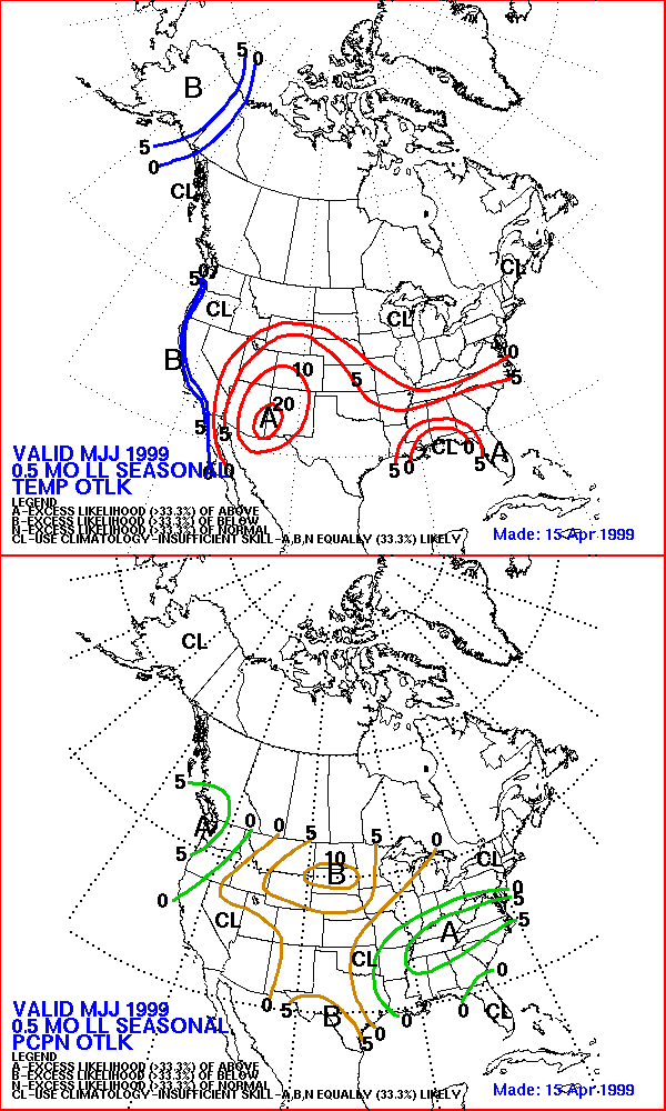
CPC 2 week lead outlook for May-June-July 1999
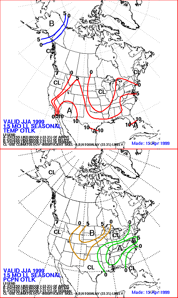
CPC 1.5 month lead outlook for June-July-August
1999
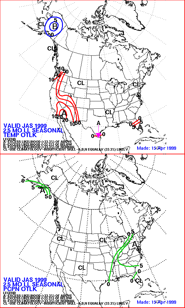
CPC 2.5 month lead outlook for
July-August-September 1999
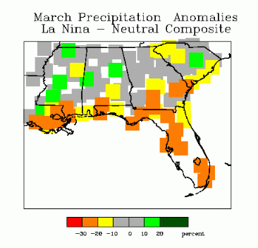
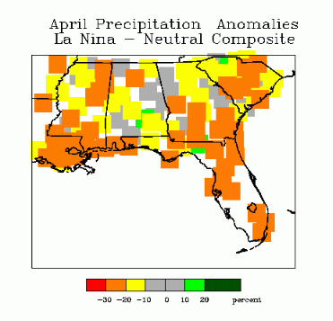
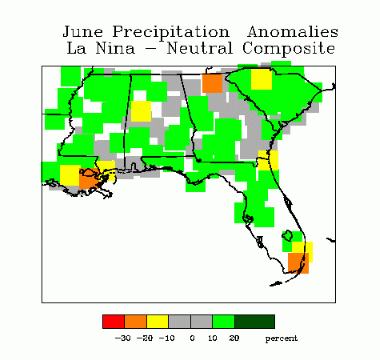
However, according to our monthly analyses of typical La Niña precipitation patterns for the Southeast, the drier than normal trend for Florida breaks in the month of May and much of the state sees an increase in precipitation. The month of June sees wetter than normal conditions across most of the Southeast. Below are precipitation trends for La Niña years for the months of March, April, May, and June.
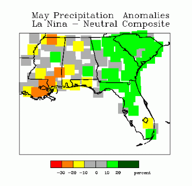
Armed with these analyses, State Climatologist Dr. James J. O'Brien boldly predicted that the drought in Florida north of Lake Okeechobee will end by the middle of May. He predicted that May rainfall for North and Central Florida will be 10-20% above normal. This prediction was made on April 22, long before the welcome rains of April 27-28.
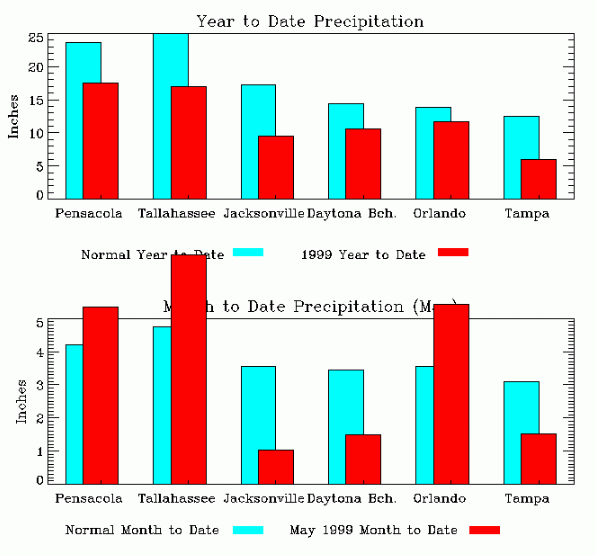
Who is right? In this section we will keep an up to date watch on yearly and monthly precipitation totals for several stations across the State.
 .
.
April 29 update
Good News! All of the stations above recorded appreciable precipitation yesterday. Daytona Beach received 1.06 inches, nearly catching up their deficit on the year. Orlando received 1.23 inches, a new record for 4/28. That amount puts them above normal for April. Yesterday's totals can be found at NWS's Daily Climate Summaries.
Here is a front page story on the drought breaking and Dr. O'Brien's prediction in the April 29 Tallahassee Democrat.
April 30 update
Most stations recieved a small amount of precipitation yesterday. Orlando was again the front runner with 0.27 inches. The others, except for Tampa, received between 0.01 and 0.20 inches.
May 4 update
There has been no rainfall since April 30. Looks like the best chance will be Thursday-Friday (May 6-7) as a cold front enters the area.
May 5 update
The panhandle recieved some rainfall in the early morning hours. Hoping for more this afternoon and tomorrow.
May 10 update
A slow-moving squall line pushed across the panhandle in the early morning hours of May 7. Panama City and Tallahassee were the big winners with Tallahasse recording 4.06 inches. Orlando also recieved over 2 inches.
May 12 update
Looks like summer patterns have begun with seabreeze induced convection across much of the state. Only the coastal stations of Jacksonville and Daytona Beach did not recieve precipitation. Expect similar showers this afternoon.
May 13 update
More seabreeze convection across the panhandle and central Florida yesterday. With upper level low digging into the Southeast, high relative humidity, and light surface winds, expect more seabreeze convection this afternoon.
May 19 update
Any rain since the last update has been isolated. Orlando recorded 2.44 inches on May 14, which puts them over the normal monthly total and nearly catches up their deficit on the year.
May 21 update
Scattered seabreeze convection in central and south Florida the past two afternoons. Panhandle is on the dry side of a dissipating front. Look for a better chance of organized rainfall early next week.
May 24 update
The rich get richer. Tallahasse received .36 inches on saturday. Pensacola, Jacksonville, and Tampa continue to fall behind. Approaching front and high relative humidities increase chances for this afternoon.
June 1 update
The western Panhandle saw a wet Memorial Day weekend with numerous thundershowers. The peninsula was much drier.
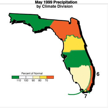
Below is a map of May precipitation compared to normal for Florida's climate divisions. The panhandle and south central florida recieve above normal precipitation while other divisions were below normal. Northeast Florida was the driest. So, Dr. O'Brien's prediction was right on for two of the climate divisions, but not for northeast Florida.
Keep in mind that the precipitation trends for La Niña years as shown in the figures above are averaged over 10 or so different events. Individual years (like 1999) can differ in probabalistic manner. In other words, even if the average La Niña conditions are for more rain than normal, an individual year still has good chance of being normal or below normal. This is especially true for time scales of only one month, where one or two weather events can dominate the outcome.
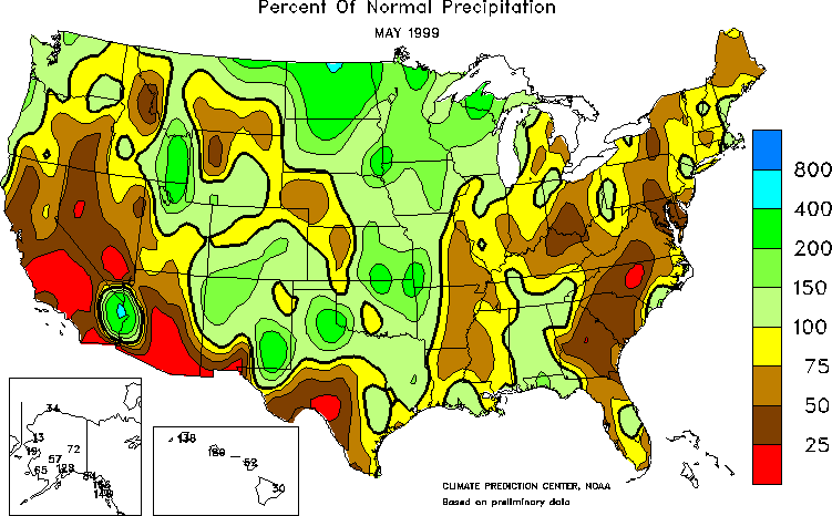
May 1999 precipitation for the U.S. (from the Climate Prediction Center)
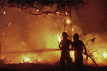
While Florida is not out of the woods yet as far as drought is concerned, we did receive enough rainfall to keep the threat of forest fires and crop damage down. The rain event of May 7 extinguished the embers of the Apalachicola National Forest fire and rains in other parts of the state were frequent enough to keep soil moisture out of the danger range. The Crop Moisture Index (CMI) stayed high enough to prevent crop damage and actually improved in south Florida.
The Main danger now is in northeast Florida. The PDSI and CMI have worsened in this area and damaging fires have swept across south Georgia. A tropical low has brought welcome rains to much of the state in the last couple of days, so let us hope that northeast Florida gets its fair share.
This page was assemble by David F. Zierden, Assistant Research
Climatologist.
Questions and comments can be sent to: zierden@coaps.fsu.edu