 Dr. Xiaobiao Xu
Principal Investigator
Ocean circulation regulates the Earth’s climate by transporting heat and carbon through the global ocean and storing heat and carbon in the deep ocean. In the Southern Ocean, the strongest current on earth, the Antarctic Circumpolar Current (ACC), distributes heat, salt/ freshwater, and carbon between ocean basins. Near the sea surface the strong westerly winds drive Ekman transport equatorward. However, throughout most of the water column, in which mean currents flow along the fronts, the ACC presents a major barrier to meridional transfers. Theory, numerical models, and sparse observations point to mesoscale eddies and standing meanders of the ACC as the primary drivers of meridional fluxes within most of the water column. The interaction of the ACC and the complex topography of the Southern Ocean concentrates cross-frontal exchange locally in a handful of locations – so called ‘hot spots’ (Thompson and Sallee, 2012). Hot spots occur where ACC fronts converge and diverge as they navigate topographic ridges and obstructions (Sokolov and Rintoul, 2009). Dynamical processes drive strong mesoscale eddy variability there in eddy-mean interaction with steering and blocking topography. The ensuing standing meanders in frontal paths produce along- isopycnal poleward heat flux. Poleward isopycnal exchange along the sloping thermocline drives upwelling (Tamsitt et al., 2018). Notable warming occurs downstream of the cross-frontal injection sites, indicative of watermass modification along the ACC path (i.e., occurring at mid- depths away from direct atmospheric forcing) (Watts et al., 2018). Exchange across the full ACC width occurs as a hand-off of heat from one front to neighboring front at successive along stream sites, allowing the heat to follow a spiral path southward (Foppert et al., 2017; Tamsitt et al., 2017). The Southern ACC Front (SACCF) presents the final barrier to heat and tracers crossing poleward. Hence its heat and carbon fluxes are of particular interest because they directly influence Southern Ocean gyres like the Ross Sea, Weddell Sea, and Antarctic slopes (Rintoul and Naveira Garabato, 2013). The goal of this project (NSF 2023210) is to quantify eddy heat fluxes across the southern ACC, warming waters around the Antarctica, using a) direct observations in an area at the Southeast Indian Ridge (SEIR, red box in Figure 1), where major ACC fronts converge closely together and exhibit strong eddy variability in the lee of the ridge complex, and b) a global eddying HYCOM simulation that represent well the structure of the ACC (Xu et al., 2020) and Atlantic meridional overturning circulation in the South Atlantic Ocean (Xu et al., 2022).
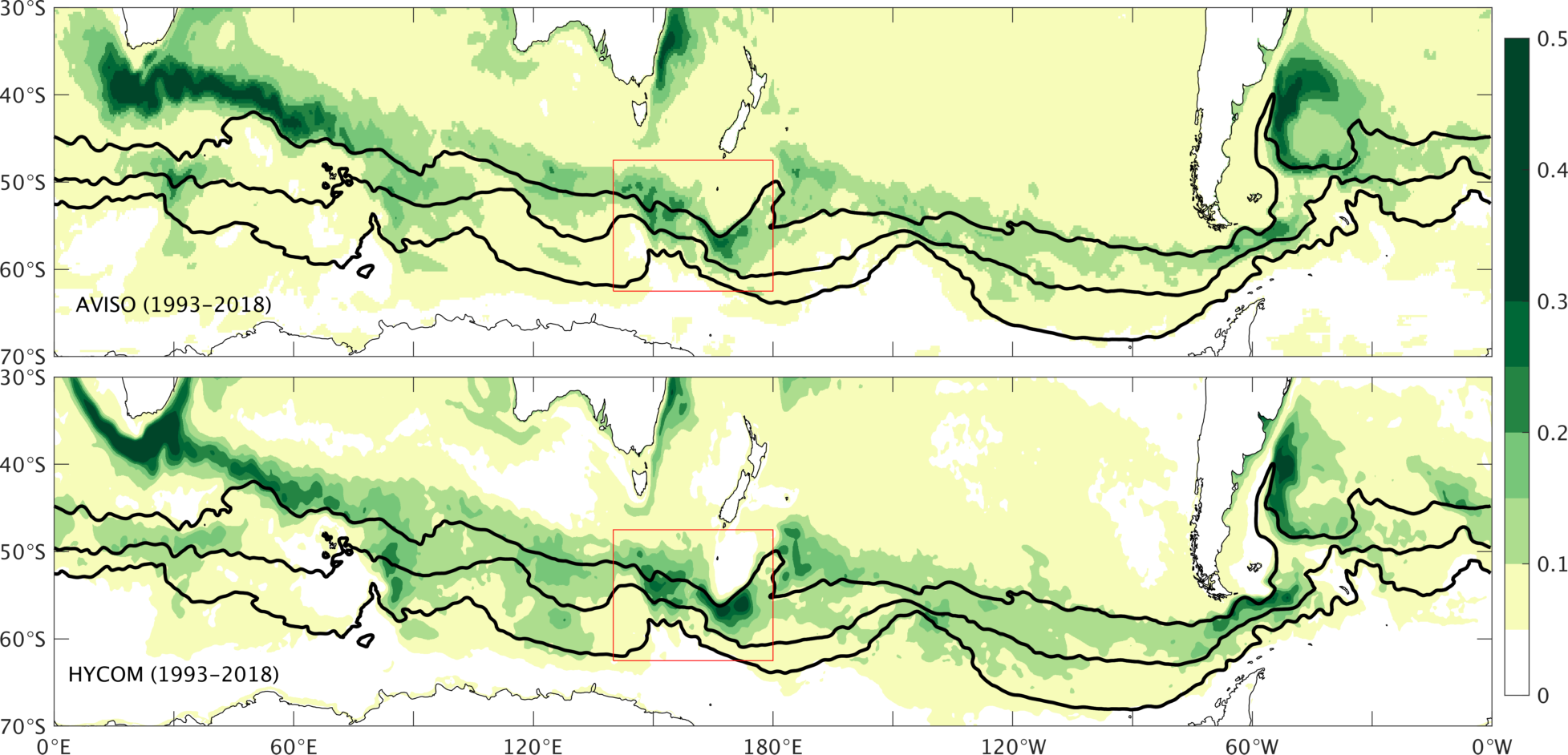 Figure 1: Sea surface height (SSH) standard deviation from satellite (top) and 1/12° global
HYCOM (bottom) for the period of 1993-2018. The SIER system is outlined in red rectangle.
Figure 1: Sea surface height (SSH) standard deviation from satellite (top) and 1/12° global
HYCOM (bottom) for the period of 1993-2018. The SIER system is outlined in red rectangle.
Research Highlights
The circulation near SEIR represented in global HYCOM simulation.We examine the capability and limitation of the 1/12° global HYCOM simulation without data- assimilation in representing the structure of the mean circulation pattern, i.e., ACC fronts in the SEIR region, such that one can place the observations into a larger scale/longer term context (if the model can represent the basic feature of the circulation observed). Figure 2 compares directly the 11-month mean bottom current from the SEIR array and from the model simulation. The time averaged current is predominantly southward, corresponding to the southward steering of the ACC front (that can be seen in sea surface height). If one examines closely, there is also a clockwise rotation of the current vector as a function of the depth (more southward flow toward bottom). Despite this subtle rotation, there is still a significant barotropic component of the velocity, so that there is a similar variability from top to bottom. These observations and model results are used to examine the dynamics of eddy fluxes across the ACC fronts (Exley et al., 2026)
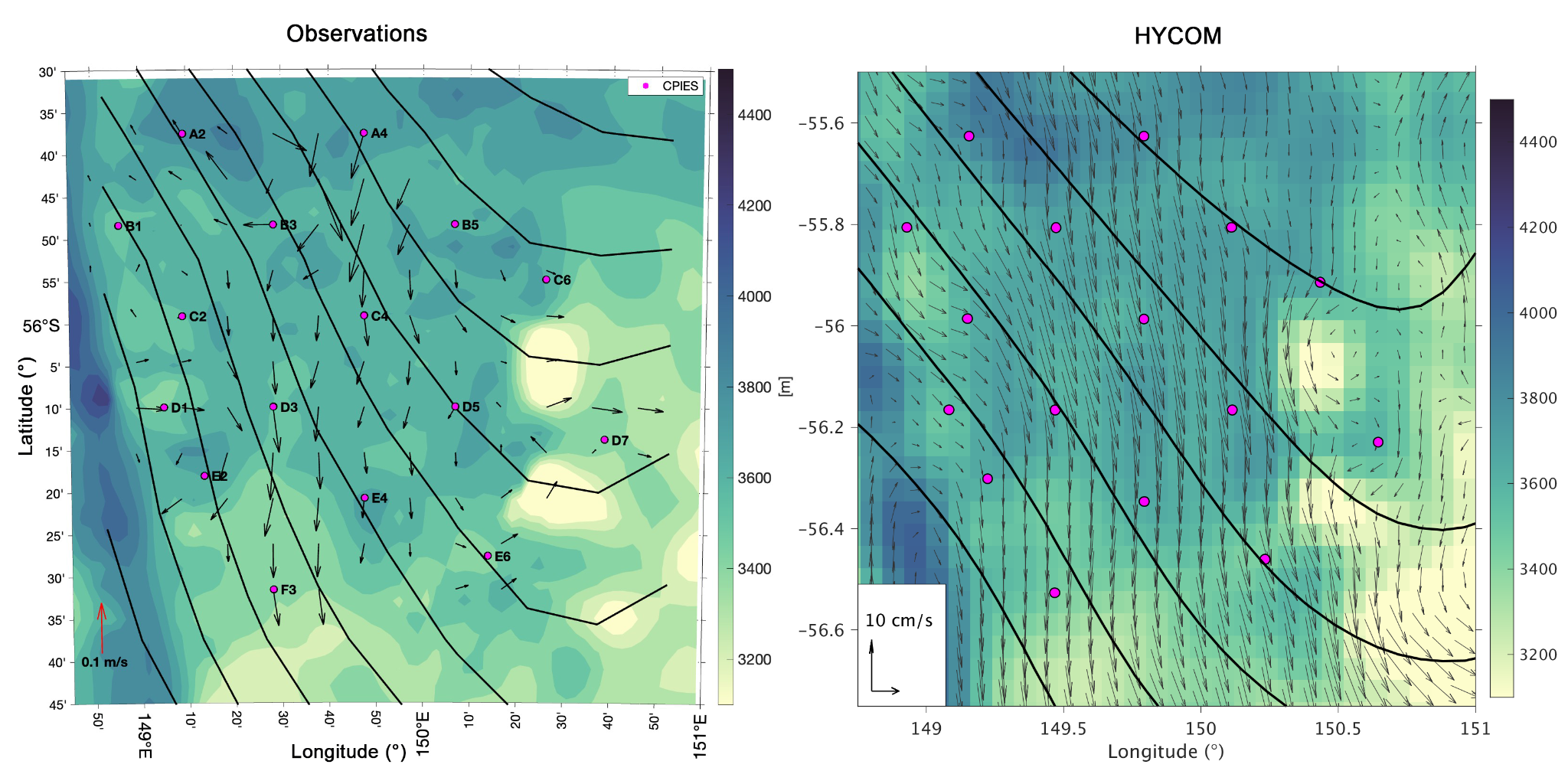 Figure 2: A direct comparison of the time averaged near-bottom current derived from
(left) CPIES array observations and (right) global HYCOM simulation over the same
observation period (of 2021/11/01-2022/09/29). The black contours are SSH indicating
a general southeast flow over this period (as compared to generally southward flow
near the bottom). Pink dots denote the location of the SEIR CPIES array.
Figure 2: A direct comparison of the time averaged near-bottom current derived from
(left) CPIES array observations and (right) global HYCOM simulation over the same
observation period (of 2021/11/01-2022/09/29). The black contours are SSH indicating
a general southeast flow over this period (as compared to generally southward flow
near the bottom). Pink dots denote the location of the SEIR CPIES array.
Heat budget of the Southern Ocean and meridional heat transports.Heat budget of the Southern Ocean and the oceanic meridional heat transport (MHT) due to time mean flow and eddy variability are displayed in Figure 3 and 4, respectively. The heat budget show that in the Southern Ocean, the heat balance between oceanic heat transport and air-sea heat flux. The ocean heat transport is contributed both from the time mean flow and temporal variability. The relative importance between these two components varies significantly across different latitudes, from ~20% near 54°S to over 90% near 38°S. The time mean flow contribution is primarily from standing eddy, whereas the variability contribution is from the transient eddy. High “localized” transient eddy contributions are found in three key regions: the Brazil-Malvinas confluence in the South Atlantic, near 85°E in the Indian Ocean, and south of Australia (near 145°E) and New Zealand (near 175°E).
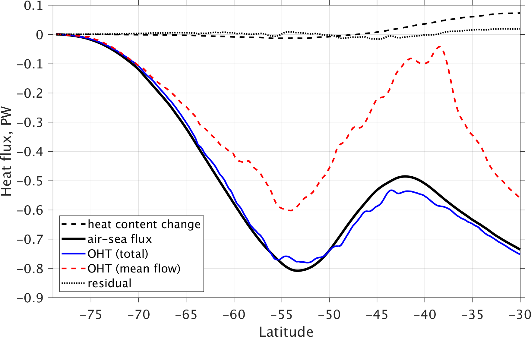 Figure 3: Heat budget of the Southern Ocean from 1/12 global HYCOM simulation over
1993-2023. Solid black line is air-sea flux, solid blue line is the ocean heat transport
(OHT), dashed black line is heat content change, dashed red line is OHT due to time
mean flow (standing eddy), and dotted black line is the residual (between heat content
change, air-sea flux, and OHT).
Figure 3: Heat budget of the Southern Ocean from 1/12 global HYCOM simulation over
1993-2023. Solid black line is air-sea flux, solid blue line is the ocean heat transport
(OHT), dashed black line is heat content change, dashed red line is OHT due to time
mean flow (standing eddy), and dotted black line is the residual (between heat content
change, air-sea flux, and OHT).
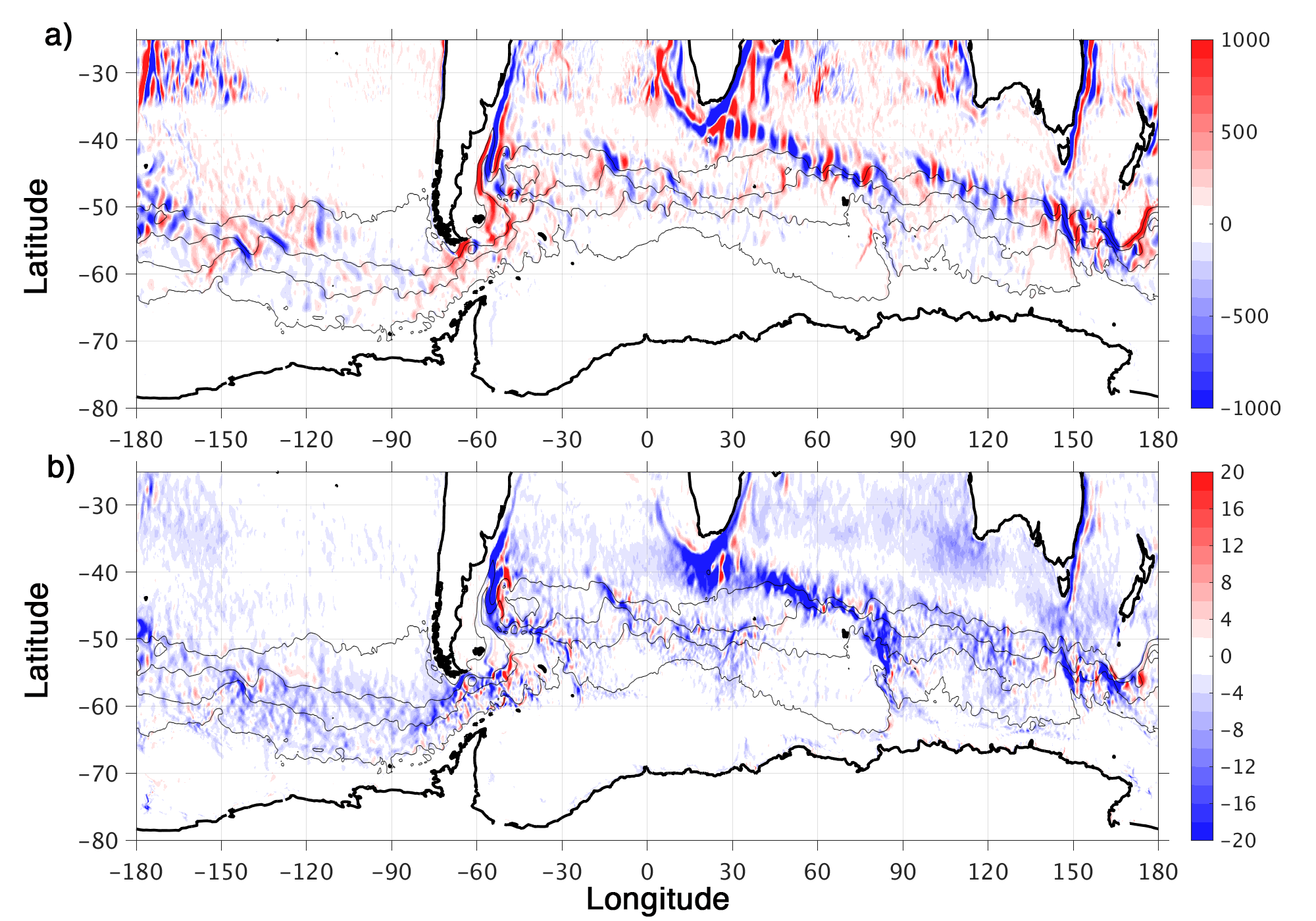 Figure 4:Spatial distribution of OHT due to a) time mean flow, and b) eddy variability.
Data availability
The original global HYCOM outputs are large and are stored in the ERDC archive
server and some of key the model results are available in HYCOM server
(https://data.hycom.org/pub/xbxu/GLBb0.08/SEIR). Further inquiries of the model
outputs can be directed to the PI of the project
References
Foppert, A., K. A. Donohue, D. R. Watts, and K. L. Tracey (2017), Eddy heat flux across the Antarctic Circumpolar Current estimated from sea surface height standard deviation, J. Geophys.Res. Oceans, 122, 6947–6964, doi:10.1002/2017JC012837.
Rintoul, S. R., and A. C. Naveira Garabato (2013), Dynamics of the Southern Ocean circulation, in Ocean Circulation and Climate - A 21st Century Perspective, International Geophysics Ser., vol. 103, edited by G. Siedler, S. M. Griffies, J. Gould, and J. A. Church, pp. 471–492, Elseveir, NY, doi:10.1016/B978-0-12-391851-2.00018-0.
Sokolov, S., and S. Rintoul (2009), The circumpolar structure and distribution of the Antarctic Circumpolar Current fronts. Part 1: mean circumpolar paths, J. Geophys. Res., 114, C11,018, doi:10.1029/2008JC005108
Tamsitt, V., R. P. Abernathey, M. R. Mazloff, J. Wang, and L. D. Talley (2018), Transformation of deep water masses along Lagrangian upwelling pathways in the Southern Ocean, J. Geophys. Res. Oceans, 123, 1994–2017, doi:10.1002/2017/JC013409.
Tamsitt, V., et al. (2017), Spiraling pathways of global deep waters to the surface of the Southern Ocean, Nat. Commun., 8, 172, doi:10.1038/241467-017-00197-0.
Thompson, A. F., and J.-B. Sall´ee (2012), Jets and topography: Jet transitions and the impact on transport in the Antarctic Circumpolar Current, J. Phys. Oceanogr., 42, 956–972.
Watts, D. R., K. L. Tracey, and K. A. Donohue (2018), Role of the Antarctic Circumpolar Current standing meanders in the downstream evolution of thermohaline properties, 2018 Ocean Sciences Meeting, abstract PL53C-03.
Xu, X., E. P. Chassignet, Y. L. Firing, and K. Donohue, 2020, Antarctic Circumpolar Current transport through Drake Passage: What can we learn from comparing high-resolution model results to observations? J. Geophys. Res. Oceans, 125, e2020JC016365, doi:10.1029/2020JC016365
Xu, X., E. P. Chassignet, S. Dong, and M. O. Baringer, 2022, Transport structure of the South Atlantic Ocean derived from a high-resolution numerical model and observations, Front. Mar. Sci., 9:811398. doi:10.3389/fmars.2022.811398.
Exley, A. J., K. Donohue, and X. Xu, 2026, Dynamics of the southern Indian Ridge storm strack evaluated using a wave activity flux framwork, Journal of Physical Oceanography, accepted.

Dr. Mark Bourassa
Principal Investigator
This project has four science components: small high latitude storms and their impacts on coastal ocean circulation; identification of wind-driven upwelling in shelf regions; characterization and understanding of the wind variability associated with the Indian Ocean Dipole; and development of a technique for realistically representing small scale variability of winds in gridded wind products. We also freely distribute the products that developed and continue to provide scatterometer L2B swath products in the simplified format that we have developed.
In a broad sense, many of the project goals examine the importance of smaller-scale wind features. For example, small Arctic storms are often missing in reanalyses; orographic features modify wind driven upwelling, ocean color and sea surface temperature; and sea surface temperature gradients and surface currents modify surface wind fields. The coupling between surface stress, SSTs and upwelling can be observed, and provides insights into the physical processes related to this coupling. The impacts of currents on air-sea coupling are more complicated and being investigated. On a larger scale, we will examine the coupling between SSTs and winds associated with the Indian Ocean Dipole, including how the winds change when the IOD changes phase. We also link these winds to rainfall on the Indian subcontinent.
Coastal upwelling zones are of great importance to marine ecosystems, regulation of local climate, and have important consequences for global climate as well. Muller-Karger et al. (2005) has estimated that more than 40% of the carbon sequestration in the ocean takes place along the continental margins where upwelling can enhance primary production, which in turn leads to biological uptake of carbon that can eventually be permanently buried in marine sediments. Historically, upwelling zones along the earth’s continental margins have been identified over very broad spatial scales and typically seasonal temporal scales. High frequency (e.g., comparable to the atmospheric synoptic variability) coastal upwelling estimates are produced for certain well studied and observed coastal regions (e.g., the western continental U.S. coast) that are known to impact well-populated and developed areas. However, many remote regions remain largely void of routine observations or monitoring, despite their potential importance to marine ecosystems and climate variability. Observations of these regions by satellite scatterometers and other sensors provide an opportunity to infer coastal upwelling-favorable conditions.
We have recently found that the coupling between stress, sea surface temperature and surface currents is highly dependent on the parameterization of stress. In this case the coupling is measured in terms of a seasonally varying relationship between the cross frontal sea surface temperature gradient and the curl of the stress (e.g., O’Neill, 2012; O’Neill et al., 2010a, 2012b; Chelton et al., 2007; Maloney and Chelton, 2006). We use the observations to provide tuning for the conversion of equivalent neutral winds to stress. As part of this investigation, a high-resolution gridded wind and stress product will be produced. Most wind products are highly smoothed, removing a large fraction of features with length scales <600 km, even when those products are made on a 25 km grid. We combine scatterometer vector winds, radiometer speeds, passive polarimetric data and sea surface temperatures to greatly improve the quality of these small-scale features. This procedure also greatly reduces the impact of sampling-related changes in the observing system. We are also examining the use of scatterometer observations to validate high resolution coupled ocean/wave/atmosphere models.
For more information about the Scatterometer-Derived Stress and Ocean Modeling Studies, visit the Scatterometry and Ocean Vector Winds website.

Shawn Smith
Principal Investigator
With their global capability and diverse array of sensors, research vessels are essential mobile observing platforms for ocean science. Data collected on every expedition are of high value, given the high cost and increasingly limited resources for ocean exploration. The Rolling Deck to Repository (R2R) program provides fleet-wide management of underway data to ensure preservation of, and access to, our national oceanographic research assets.
R2R routinely catalogs and deposits data in long-term public archives, including the NOAA National Centers for Environmental Information (NCEI) (for data) and Chronopolis (for documents). Data from each cruise are submitted directly to R2R by the vessel operator, rather than by the science party. R2R provides essential documentation and standard products for each expedition, as well as tools to document shipboard data acquisition activities while underway. Post-cruise quality assessment of selected underway data types is supported, including feedback to ship technicians.
Assessment of underway meteorological data is implemented in near-real-time in partnership with the SAMOS program at FSU.
For more information about the R2R, visit the Rolling Deck to Repository (R2R) website.
Dr. Xiaobiao Xu
Principal Investigator
Large-scale ocean circulations can be sensitive to relatively small regions where there is intense mean current, significant air-sea interaction, and thermodynamic water mass transformation. One such high-energy region lies east of the northern US and Canadian coasts (indicated by a yellow box in Fig. 1). Here, the Gulf Stream extension along with the eastward-flowing slope-water current splits into three branches, including i) the inertial recirculation gyres north and south of the Gulf Stream; ii) the basin-filling subtropical gyre, and iii) the North Atlantic Current (NAC) as the northward limb of the Atlantic meridional overturning circulation (AMOC). Inshore and beneath the NAC, the southward flowing western boundary current along the Labrador Coast also splits into multiple branches, including: 1) some retroflects northward and then eastward as the subpolar gyre, 2) some shelf water flow around the Grand Banks and westward into the North Atlantic Bight, and 3) the North Atlantic Deep Water (NADW) continues its equatorial journey as the lower limb of the AMOC. The unique location of this transition region as a meeting point for both the subtropical-subpolar gyres and the upper-lower AMOC branches has been recognized for many years (e.g., Iselin, 1936; Worthington, 1976; Rossby, 1996). However, as summarized in Lozier (2010), it remains unclear how water in both the upper and lower limbs of the AMOC flows through this complex region before entering the subpolar and subtropical regimes. In this project (NSF award # 1537136), we are systematically investigating the upper and lower layer circulation that connected to transition region, using high-resolution numerical models, together with observations.
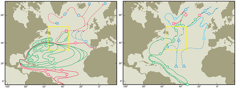 Figure 1: Large-scale circulation schematics of the North Atlantic for the upper layer (θ>7°C, Left panel) and lower layer (1.6 <θ <4°C, right panel) from Schmitz (1996). Yellow box indicates the Gulf Stream to North Atlantic Current transition region. Transports numbers in squares denote sinking; in triangles, upwelling; and in hexagons, entrainment.
Research Highlights
The impact of horizontal resolution on Gulf Stream Separation, Penetration, and Variability. Three nearly identical simulations with horizontal resolution of 1/12°, 1/25°, and 1/50° is used to investigate the separation, penetration, and variability of the Gulf Stream (Chassignet and Xu, 2017). The results show that the representation of Gulf Stream penetration and associated recirculation gyres shifts from unrealistic to realistic when the resolution is increased to 1/50° and when the nonlinear effects of the sub-mesoscale eddies intensifies the mid-latitude jet and increases its penetration eastward (see the very wide range of eddy scale as illustrated in surface vorticity in Fig. 2). The study also shows that at 1/50° resolution, the penetration of eddy kinetic energy into the deep ocean is drastically improved and resembles the observations. The surface power spectra in the mesoscale range are representative of interior quasi-geostrophic (QG) and surface quasi-geostrophic (SQG) turbulence, independent of the horizontal resolution and of the latitude.
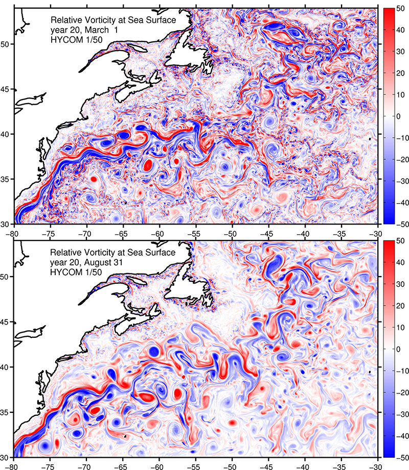 Figure 2: Relative vorticity at sea surface in the Gulf Stream-North Atlantic Current region during winter (top panel) and summer (bottom panel) based on a 1/50° Atlantic simulation using HYCOM.
Transport variability of the Iceland-Scotland Overflow water in the Charlie-Gibbs Fracture Zone. Iceland-Scotland Overflow water (ISOW) is a key component of the North Atlantic Deep Water that flow southward in the Atlantic as the lower limb of the AMOC. Knowledge of the circulation pathway (schematic in Fig. 3) and its volume transport (including variability) associated with the ISOW is fundamental in understanding the AMOC. Two substantial ISOW observations are made at a critical location-the Charlie-Gibbs Fracture Zone, and both show very large temporal variability, with frequent reversals of the flow (Saunders 1994; Bower and Furey 2017). In a recent work, Xu et al., (2018 manuscript to JGR-Ocean under review) show that most of the observed variability can be reproduced in their high resolution simulation using the HYbrid coordinate ocean model (HYCOM) with atmospheric forcing (Fig. 3). The model results are then used to help understand the source of the ISOW variability and to put the observed variability into a larger scale context: the variability is most likely induced by fluctuations of large-scale east-west wind anomaly; the ISOW variability of the ISOW at the CGFZ does not come from the upstream source, and is anti-correlated with the variability of the southward transport along the eastern flank of the Mid-Atlantic Ridge.
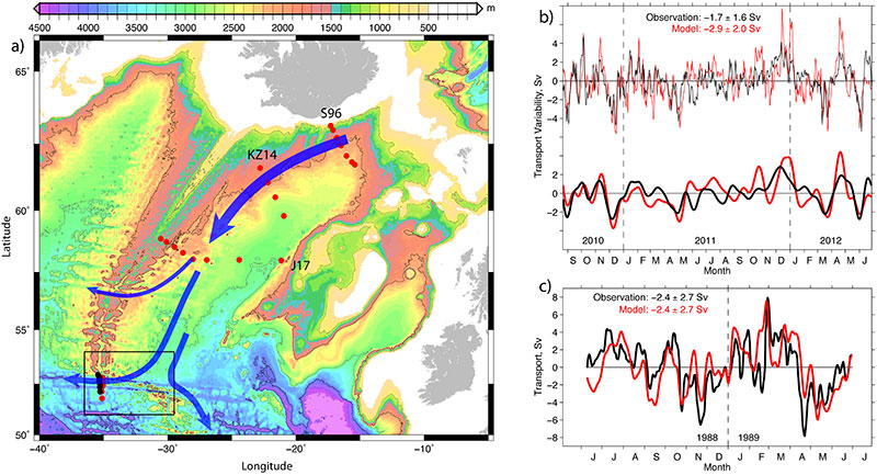 Figure 3: a) Schematic of Iceland-Scotland Overflow Water (ISOW) circulation in the Iceland Basin along with location of Key observations (The black box indicate the Charlie-Gibbs Fracture Zone); b-c) A comparison of the observed and modeled ISOW transport through the CGFZ in two periods 1988-1989 and 2010-2012.
For more information about this research, contact
Submitted Manuscript & Publications
LaCasce, J., J. Escartin, E. P. Chassignet, and X. Xu, 2018, Instability over topography, manuscript to J. Phys. Oceanogr. (submitted)
Xu, X., E. P. Chassignet and F. Wang, 2018, On the variability of the Atlantic meridional overturning circulation transports in couple CMIP5 simulations, manuscript to Climate Dynam. (revised)
Xu, X., A. Bower, H. Furey, and E. P. Chassignet, 2018, Variability of the Iceland-Scotland overflow water transport through the Charlie-Gibbs Fracture Zone: results from an eddying simulation and observations, manuscript to J. Geophys. Res. Oceans. (accepted)
Xu, X., P. B. Rhines, and E. P. Chassignet, 2018, On mapping the diapycnal water mass transformation of the upper North Atlantic Ocean, manuscript to J. Phys. Oceanogr. (accepted)
Chassignet, E. P. and X. Xu, 2017, Impact of horizontal resolution (1/12° to 1/50°) on Gulf Stream separation, penetration, and variability, J. Phys. Oceanogr., 47(08), 1999-2021, doi: 10.1175/JPOD-17-0031.1.
Xu, X., P. B. Rhines, and E. P. Chassignet, 2016, Temperature-salinity structure of the North Atlantic circulation and associated heat and freshwater transports, J. Climate, 29(21), 7723-7742, doi:10.1175/JCLI-D-15-0798.1.
Xu, X., P. B. Rhines, E. P. Chassignet, and W. J. Schmitz Jr. (2015): Spreading of the dense overflow water in the western subpolar North Atlantic: insights from eddy-resolving simulations with passive tracer. J. Phys. Oceangr., 45(12), 2913-2932, doi: 10.1175/JPO-D-14-0179.1.
References
Bower, A. S., and H. Furey (2017). Iceland-Scotland overflow Water transport variability through the Charlie-Gibbs Fracture Zone and the impact of the North Atlantic Current. J. Geophys. Res.: Oceans
Iselin, C. O. D. (1936): A study of the circulation of the western North Atlantic, Pap. Phys. Oceanogr. Meteorol., 4, 101 pp., Cambridge, MA, Woods Hole Oceanographic Institution.
Lozier, M. S. (2010): Deconstructing the conveyor belt, Science, 328, 1507–1511.
Rossby, T. (1996): The North Atlantic Current and surrounding waters: At the crossroads, Rev. Geophys., 34 (4), 463-481.
Saunders, P. M. (1994), The flux of overflow water through the Charlie‐Gibbs fracture zone, J. Geophys. Res., 99(C6), 12,343–12,355, doi:10.1029/94JC00527.
Schmitz Jr., W. J. (1996): On the world ocean circulation: Volume I, Some Global Features/North Atlantic Circulation, Technical Report WHOI-96-03, Woods Hole Oceanographic Institution, Woods Hole, Massachusetts.
Worthington, L. V. (1976): On the North Atlantic Circulation (Vol. 6), Johns Hopkins University Press, Baltimore, Md.
 Dr. Eric Chassignet
Principal Investigator
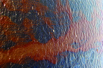
The Deepwater Horizon oil spill resulted in an unprecedented commitment to study and better understand different aspects of the fate of oil released in northeast region of the Gulf of Mexico in 2010. Countless research teams have spent considerable resources developing modeling tools, collecting and analyzing measurements, and performing scientific studies to understand different aspects governing the eventual fate of the oil. Together, these data have provided the basis for development of vastly improved modeling tools for tracking the distribution and chemical evolution of oil. But one area where our understanding remains quite limited is the role that microbes play in determining the eventual fate of oil and its impact on ecosystems, and how these processes depend on environmental conditions (hydrographic and biogeochemical properties of the water and circulation), hindering predictive capability.
The CSOMIO project is working to synthesize the technology, tools, and scientific knowledge of a group of individual investigators some of whom, since the Deepwater Horizon event, have immersed themselves in this study. The Consortium also brings to the study investigators who can fill critical gaps in our ability to numerically model the transport and fate of oil in coastal waters. The goal is to produce a comprehensive framework for simulating and understanding the role that microbes play in mitigating the impacts of oil spills. This model system will be an open source product that can potentially be run in a variety of locations with different physical forcing models. Expected outcomes include the ability to predict the impact of oil spills occurring under different temperature, hydrodynamic, and biogeochemical regimes, a consistently annotated synthesis of genomic and transcriptomic data for the Gulf of Mexico, and the elucidation of mechanisms relating hydrocarbon degradation to microbial community dynamics, flocculation, and sediment transport processes.
For more information about this consortium, visit the CSOMIO website.
Featured Projects
Current Projects
-
A Data Serving Platform for HYCOM Ocean Prediction System Outputs in Support of ESPC
-
A Service to Match Satellite and In-Situ Marine Observations to Support Platform Intercomparisons
-
Accelerated Prediction of the Polar Ice and Global Ocean (APPIGO)
-
An Integration and Evaluation Framework for ESPC Coupled Models
-
Arctic Shelf and Large Rivers Seamless Nesting in Global HYCOM
-
Climate Variability in Ocean Surface Turbulent Fluxes
-
Consortium for Simulation of Oil-Microbial Interactions in the Ocean
-
Development of a Prototype of an Automated Management System for the KPOPS Quasi-Real Time Climate Prediction Modeling System
-
Evaluation and Diagnosis of the Atlantic Meridional Overturning Circulation
-
Florida Public Hurricane Loss Model
-
FSU Services for the Office of Marine and Aviation Operations
-
Further Refinements to Stepped-Frequency Microwave Radiometer Surface Wind
-
Improving Hurricane Forecasts Using Multimodel Ensembles through Neural Network Approaches
-
MarineFlux: A user friendly in-situ marine turbulent flux data service
-
Modeling Climate Impacts on Fish Larvae Mortality in the Gulf of Mexico
-
New Frontiers of Operational Oceanography
-
New Frontiers of Operational Oceanography - Participant Support Costs
-
Ocean and Sea Ice and their Interactions Around Greenland and the West Antarctic Peninsula
-
Ocean Eddies - Topographic Interactions Along the Brazilian Coast
-
Ocean Modeling and Prediction
-
Preliminary Steps Toward a National Ocean Modeling Capability in Support of the National Earth System Prediction Capability
-
SAMOS Data Management for the R/V Falkor (too)
-
Spatiotemporal Inhomogeneity of Tropical Waves and Their Interactions
-
Surface Turbulent Energy and Moisture Fluxes Based on Satellite Data
-
U.S. Research Vessel (SAMOS) Data Assembly Center
-
Ultra-Thin Surface Drifter Observations for SPURS-2
-
Using Remote Sensing & Environmental Data to Quantify Social Vulnerabilities to Heat Stress & Strengthen Environmental Public Health Tracking & Heat Mitigation Efforts
Past Projects
-
20th Century Atlantic Surface Wind Indices
- Deep-C Consortium
-
GCOOS N-7 Tower Project
Gulf of Mexico Coastal Ocean Observing System (coaps.fsu.edu/gcoos)
-
SAMOS Data Management for the R/V Falkor
-
U.S. National Park Service
A partnership with the Southeast Archeological Center (coaps.fsu.edu/nps)
Building A, Suite 292
Tallahassee, FL 32306-2741
Phone: (850) 644-4581
Fax: (850) 644-4841
contact@coaps.fsu.edu
© Center for Ocean-Atmospheric Prediction Studies (COAPS), Florida State University